Scottown Covered Bridge
|
Scottown Covered Bridge | |
 | |
 | |
| Nearest city | Scottown, Ohio |
|---|---|
| Coordinates | 38°32′52″N 82°22′49″W / 38.54778°N 82.38028°WCoordinates: 38°32′52″N 82°22′49″W / 38.54778°N 82.38028°W |
| Area | less than one acre |
| Built | 1874, 1934 |
| Architectural style | Multiple Kingpost |
| NRHP reference # | 75001456[1] |
| Added to NRHP | November 12, 1975 |
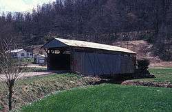
The Scottown Covered Bridge, near Scottown, Ohio, was built in 1874. It was listed on the National Register of Historic Places in 1975. It is a Multiple Kingpost covered bridge.[1]
It spans Indian Guyan Creek and is 85 feet (26 m) long. It has a corrugated metal roof. It is a multiple Kingpost and Queenpost bridge.
It is located east of Scottown on State Route 67 in Windsor Township, Lawrence County, Ohio
It was built in 1877. It survived several floods early in its history. It was modified in 1934 by the addition of a Burr Arch and steel tie rods.[2]
It is covered in the Ohio Historic Places Dictionary.[3]
References
- 1 2 National Park Service (2013-11-02). "National Register Information System". National Register of Historic Places. National Park Service.
- ↑ Harold Stiver (July 12, 2016). "Nature Notes: Scottown Covered Bridge". Retrieved September 8, 2018.
- ↑ Lorrie K. Owen, ed. (1999). "Ohio Historic Places Dictionary, Volume 2". Somerset Publishers, Inc. p. 858. Retrieved September 8, 2018.
| Topics | |
|---|---|
| Lists by states |
|
| Lists by insular areas | |
| Lists by associated states | |
| Other areas | |
| |
This article is issued from
Wikipedia.
The text is licensed under Creative Commons - Attribution - Sharealike.
Additional terms may apply for the media files.