Schonstett
| Schonstett | ||
|---|---|---|
| ||
 Schonstett Location of Schonstett within Rosenheim district 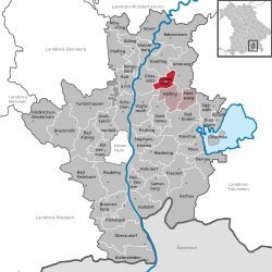 | ||
| Coordinates: 47°59′N 12°15′E / 47.983°N 12.250°ECoordinates: 47°59′N 12°15′E / 47.983°N 12.250°E | ||
| Country | Germany | |
| State | Bavaria | |
| Admin. region | Oberbayern | |
| District | Rosenheim | |
| Municipal assoc. | Halfing | |
| Government | ||
| • Mayor | Josef Fink (CSU) | |
| Area | ||
| • Total | 13.60 km2 (5.25 sq mi) | |
| Elevation | 492 m (1,614 ft) | |
| Population (2017-12-31)[1] | ||
| • Total | 1,367 | |
| • Density | 100/km2 (260/sq mi) | |
| Time zone | CET/CEST (UTC+1/+2) | |
| Postal codes | 83137 | |
| Dialling codes | 08055 | |
| Vehicle registration | RO | |
| Website | www.schonstett.de | |

Schonstett is a municipality in the district of Rosenheim in Bavaria in Germany.
History
In the Middle Ages, Schonstett was the capital of the dominion of the Baron of Schleich. In the course of the 1818 administrative reform in Bavaria Schonstett became an independent municipality.
Culture and sights
- Saint John the Baptist (parish church)
- Castle and castle gardens
Sports
- SV Schonstett
- Schloßschützen (marksmen)
Education
- Grundschule Schonstett (elementary school)
- Kindergarten "Fridolin Pusteblume" (nursery)
Youth
- KLJB Schonstett (for Catholic rural youth)
References
- ↑ "Fortschreibung des Bevölkerungsstandes". Bayerisches Landesamt für Statistik und Datenverarbeitung (in German). September 2018.
External links
This article is issued from
Wikipedia.
The text is licensed under Creative Commons - Attribution - Sharealike.
Additional terms may apply for the media files.