Schley, North Carolina
| Schley | |
|---|---|
| Unincorporated community, | |
 Schley Location within the state of North Carolina | |
| Coordinates: 36°09′10″N 79°03′41″W / 36.15278°N 79.06139°WCoordinates: 36°09′10″N 79°03′41″W / 36.15278°N 79.06139°W | |
| Country | United States |
| State | North Carolina |
| County | Orange |
| Elevation | 584 ft (178 m) |
| Time zone | UTC-5 (Eastern (EST)) |
| • Summer (DST) | UTC-4 (EDT) |
| GNIS feature ID | 994411 |
Schley (pronounced Sly) is an unincorporated community, in Orange County, North Carolina, southwest of Caldwell, North Carolina, and northeast of Hillsborough, North Carolina. It lies at an elevation of 584 feet (178 m). [1]
One of the main landmarks in the area is the Schley Grange Hall at the intersection of Hwy 57 and Schley Road. Schley has a very active farming community.

Schley Grange Hall on the 4th of July.
References
Municipalities and communities of Orange County, North Carolina, United States | ||
|---|---|---|
| Cities | 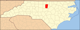 | |
| Towns | ||
| CDPs | ||
| Unincorporated communities | ||
| Footnotes | ‡This populated place also has portions in an adjacent county or counties | |
This article is issued from
Wikipedia.
The text is licensed under Creative Commons - Attribution - Sharealike.
Additional terms may apply for the media files.