Calvander, North Carolina
| Calvander, North Carolina | |
|---|---|
| Unincorporated community | |
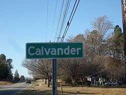 Entering from the south via Old NC 86 | |
 Location of Calvander in North Carolina  Calvander, North Carolina (the US) | |
| Coordinates: 35°56′35″N 79°06′35″W / 35.94306°N 79.10972°WCoordinates: 35°56′35″N 79°06′35″W / 35.94306°N 79.10972°W | |
| Country | United States |
| State | North Carolina |
| County | Orange |
| Elevation[1] | 548 ft (167 m) |
| Time zone | UTC-5 (Eastern (EST)) |
| • Summer (DST) | UTC-4 (EDT) |
| ZIP code | 27516 |
| Area code(s) | 919 |
| GNIS feature ID | 982437[1] |
Calvander is a rural unincorporated community in southeastern Orange County, North Carolina, United States north-northwest of Carrboro. It lies at the intersection of Old North Carolina Highway 86 (Chapel Hill, North Carolina), and Homestead/Dairyland Road.
References
- 1 2 "Calvander, North Carolina". Geographic Names Information System. United States Geological Survey. . Retrieved on 2008-03-31.
Municipalities and communities of Orange County, North Carolina, United States | ||
|---|---|---|
| Cities | 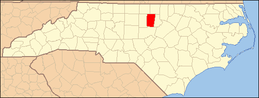 | |
| Towns | ||
| CDPs | ||
| Unincorporated communities | ||
| Footnotes | ‡This populated place also has portions in an adjacent county or counties | |
This article is issued from
Wikipedia.
The text is licensed under Creative Commons - Attribution - Sharealike.
Additional terms may apply for the media files.