Scarrington
Coordinates: 52°57′57″N 0°54′25″W / 52.965834°N 0.906966°W Scarrington is a civil parish and village in the Rushcliffe borough of Nottinghamshire, adjacent to Bingham, Car Colston, Hawksworth, Orston and Aslockton. The parish, with a population in 2011 of 183[1] and an area of 973 acres (394 ha), lies at Ordnance Survey grid reference SK7341, in the undulating farmland of the Vale of Belvoir, some 2 miles (3.2 km) from the town of Bingham and from the section of the Fosse Way (A46) between Newark and Leicester.[2] It is skirted by the A52 road between Nottingham and Grantham. The nearest railway station is at Aslockton.
Governance
Most local government functions are performed by Rushcliffe Borough Council. The borough election results on 7 May 2015 confirmed Conservative control. Scarrington lies in Bingham East ward, which is represented by George Davidson (Independent). Scarrington's population qualifies it only for a twice-yearly Parish Meeting, not a Parish Council.[3]
The local member of Parliament for Rushcliffe is the Conservative Kenneth Clarke.
Toponomy
Scarrington may contain the Old English word, scearnig meaning dirty, filthy or mucky, + tun (Old English), an enclosure; a farmstead; a village; or an estate, so perhaps "Dirty farm or settlement".[4]
Heritage

A flint sickle blade found at Scarrington in 1981 was dated to the late Neolithic age.[5] There is also evidence that Scarrington was inhabited in Roman times (in the 2nd or 3rd century AD), in the shape of tools and remains of a villa. These were found during the laying of a water pipe in February/March 1991 between the village and Car Colston.[6] Scarrington is noted in Domesday Book in 1086 as "Scarintone" and as belonging to the king. It had 27 households.[7]
Scarrington and Aslockton shared several landowners and could be covered by a joint enclosure act in 1781.[8] The population of Scarrington was 152 in 1801, 171 in 1821, and 188 in 1831.[9] The size of the village changed little from the time of the enclosure up to the 20th century, when some development took place northward along Hawksworth Road. A few working farms remain today, but most inhabitants commute to work or school.[2] Scarrington was in Bingham Rural District up to 1974 and before 1894 in Bingham Wapentake.
The village lies mainly within a conservation area declared in 1990 and extended in October 2010. This includes four listed buildings, mature trees and wide grass verges. There is a unique 15 ft (4.88 m) pile of horseshoes outside the Grade II listed Smithy.[10] It stands 17 ft (5.18 m) high and consists of some 50,000 horseshoes. It was constructed by the village blacksmith between about 1945 and 1965, while working in the adjacent Old Forge.[11]
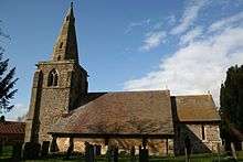
The medieval Anglican parish Church of St John of Beverley, Scarrington, a 13th-century building restored by J. H. Hakewill in 1867–69, is Grade I listed.[12][13] The belfry has three bells dated 1450.[14]

A Methodist chapel was built in 1818.[15]
Another Grade II listed edifice is the village pinfold opposite the Smithy. It has 1.83 m brick walls with copings and is unusual in being circular. However, the pinfolds at nearby Flintham and Screveton are also circular, and it has been suggested that all three were built by the same unidentified builder in the 19th century. Scarrington's has a diameter of 6.1 m. Renovation was carried out on it in 1988 and 2012.[16]
The village's third Grade II listed building is the old hall, Scarrington House in Hawksworth Road, built about 1700 for the Shipman family, who had been prominent in the village since Elizabethan times.[17]
There was a hamlet of some 16 cottages known as Little Lunnon to the south of Scarborough. These were thatched dwellings of poor quality built in the mid-18th century to house the "impotent poor", under powers given to parish overseers under the Elizabethan Poor Law Act of 1601. That purpose was strictly served until the passage of the Poor Law Amendment Act 1834, after which the destitute poor were sent to Bingham workhouse instead, but many of the Little Lunnon cottages remained occupied. The last two derelict cottages were demolished by the council as uninhabitable in 1945.[18] Many houses for the poor in earlier centuries were built on waste land, which may explain why the hamlet stood apart from the village.[19][20]
Here is an extract from A Topographical Dictionary of England (London: S. Lewis, 1848): "SCARRINGTON, a parish, in the union, and N. division of the wapentake, of Bingham, S. division of the county of Nottingham, 12½ miles (E. by N.) from Nottingham; containing 230 inhabitants. The living is annexed to the vicarage of Orston: the tithes were commuted for land and money payments in 1780. There is a place of worship for Wesleyans."[21] The ecclesiastical link with Orston lasted until February 1867, when the chapelry of Scarrington was combined with that of Aslockton (hitherto under Whatton) to make a new vicarage: Scarrington-with-Aslockton.[22] The two villages became ecclesiastically separate again in 1919, when Aslockton's new church was attached to Whatton's.[23]
Amenities
Scarrington has only twice-weekly bus services – service 856 runs between Lowdham and Bottesford via Bingham twice in each direction on Tuesdays and Thursdays.[24] The nearest stop regularly served is at Dawn's Lane, Aslockton (1.5 miles, 2.4 km), from where there are five buses per weekday between Bottesford and Nottingham.[25] Aslockton railway station (1.3 miles, 2.1 km) has trains every one or two hours in the directions of Nottingham and Grantham and beyond.
Scarrington has a used-car dealer in Main Street[26] and a laundry at Manor Farm.[27] Otherwise the nearest retail, medical and professional services are in Bingham. There is a filling station at Saxondale (3 miles, 4.8 km). The Cranmer Arms in Aslockton and the Royal Oak in Car Colston (2 miles, 3.2 km) are the nearest pubs.
There are primary schools in Aslockton and Bingham.[28] Toot Hill School in Bingham is a secondary school with a sixth form and academy status.[29] The premises of Scarrington's old school in Aslockton Road now form a private house.[18][30] Until the mid-1950s, there was also a private junior school operating at The White House in Main Street.[31] It was run by Dorothy Standish (1887–1973),[32] daughter of Rev. John Standish, who had been vicar of the Scarrington/Aslockton parish from 1885 until his death in 1918.[33]
Scarrington parish church has a service on the third Sunday of every month at 5 pm and on major church festivals. It forms part of the Cranmer group of parishes in the Diocese of Southwell and Nottingham.[34] Scarrington Methodist Church in Main Street has a 6 pm service on alternate Sundays and a monthly Bible study session. It belongs to the Grantham and Vale of Belvoir Circuit.[35]
Scarrington's Women's Institute (WI) meets at the WI Hall, Hawksworth Road, on the first Thursday of the month at 7.30 pm.[36]
Notable people
- Thomas Shipman (1632–1680), royalist poet, playwright and landowner, was born in Scarrington, baptised there in November 1632, and died there on 15 October 1680.[37][38]
- Sarah Churm (born 1980), television actress, was born in Scarrington.[39]
References
- ↑ "Civil Parish population 2011". Neighbourhood Statistics. Office for National Statistics. Retrieved 15 April 2016.
- 1 2 Scarrington Appraisal and Management Plan Retrieved 1 January 2016.
- ↑ Parish Councils Retrieved 1 January 2016.
- ↑ J. Gover, A. Mawer & F. M. Stenton (eds.), Place Names of Nottinghamshire (Cambridge, 1940), p.228; A.D.Mills, Dictionary of English Place-Names (Oxford, 2002), p.303; E .Ekwall, Concise Oxford Dictionary of English Place-names (Oxford, 1960), p.407
- ↑ Liddon, Anne: Antiquity 56.216 (1 March 1982) Retrieved 4 January 2016.
- ↑ Trent and Peak Archaeological Trust Retrieved 4 January 2016.
- ↑ Open Domesday Retrieved 16 January 2016.
- ↑ Aslockton Local History Retrieved 16 January 2016.
- ↑ William White: History, Gazetteer and Directory of Nottinghamshire... (Sheffield, 1832), p. 479. Retrieved 3 April 2016.
- ↑ Rushcliffe. Retrieved 1 January 2016.
- ↑ Nottinghamshire Villages Retrieved 13 June 2017.
- ↑ Historic England. "Church of St John of Beverley (1272713)". National Heritage List for England. Retrieved 1 January 2016.
- ↑ Nikolaus Pevsner: The Buildings of England: Nottinghamshire (Harmondsworth, United Kingdom: Penguin, 1979), p. 304.
- ↑ St John of Beverley site Retrieved 4 January 2016.
- ↑ William White: History, Gazetteer and Directory of Nottinghamshire... (Sheffield, 1832), p. 504. Retrieved 3 April 2016.
- ↑ Waymarking. Retrieved 1 January 2016.
- ↑ British Listed Buildings Retrieved 26 February 2016.
- 1 2 Notts Villages Retrieved 1 January 2016.
- ↑ Undated Newark Advertiser article "Homes made of mud" Retrieved 4 January 2016.
- ↑ Our Nottinghamshire Retrieved 16 January 2016.
- ↑ Quoted in British History Online Retrieved 1 January 2016.
- ↑ John Thomas Godfrey: Notes on the Churches of Nottinghamshire: Hundred of Bingham (Phillimore, 1907), p. 346.
- ↑ Aslockton St Thomas Retrieved 22 February 2016.
- ↑ Bus Times Retrieved 16 January 2016.
- ↑ Bus timetable Retrieved 1 January 2016.
- ↑ Business site Retrieved 16 January 2016.
- ↑ Business page Retrieved 26 February 2016.
- ↑ School Finder Retrieved 1 January 2016.
- ↑ Toot Hill School Retrieved 7 February 2016.
- ↑ Zoopla Retrieved 2 January 2016.
- ↑ Cranmer Local History Group Retrieved 1 January 2016.
- ↑ Rootspoint Retrieved 22 February 2016.
- ↑ Europeana Collections Retrieved 22 February 2016.
- ↑ A Church Near You Retrieved 1 January 2016.
- ↑ Circuit website Retrieved 1 January 2016.
- ↑ The WI Retrieved 16 January 2016.
- ↑ Wikisource Retrieved 22 February 2016.
- ↑ Robert Wilcher, "Shipman, Thomas (1632–1680)", Oxford Dictionary of National Biography (Oxford, UK: Oxford University Press, 2004 Retrieved 25 February 2016.
- ↑ IMDb Retrieved 16 January 2016.
External links
| Wikimedia Commons has media related to Scarrington. |
- Map of Scarrington Conservation Area Retrieved 1 January 2016.
- Scarrington Appraisal and Management Plan Retrieved 1 January 2016.
- Hand-drawn Ordnance Survey map of Scarrington, 1883–99 Retrieved 16 January 2016.
- A large number of photographs of Scarrington Retrieved 16 January 2016.
- Short account of a 2013 lecture on the Scarrington-born poet Thomas Shipman Retrieved 26 February 2016.