Saxtons River, Vermont
| Saxtons River, Vermont | |
|---|---|
| Village | |
 | |
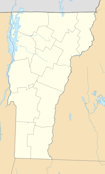 Saxtons River, Vermont Location within the state of Vermont | |
| Coordinates: 43°8′18″N 72°30′33″W / 43.13833°N 72.50917°W | |
| Country | United States |
| State | Vermont |
| County | Windham |
| Area | |
| • Total | 0.5 sq mi (1.3 km2) |
| • Land | 0.5 sq mi (1.3 km2) |
| • Water | 0.0 sq mi (0.0 km2) |
| Elevation | 466 ft (142 m) |
| Population (2010) | |
| • Total | 565 |
| • Density | 1,130/sq mi (436.6/km2) |
| Time zone | UTC-5 (Eastern (EST)) |
| • Summer (DST) | UTC-4 (EDT) |
| ZIP code | 05154 |
| Area code(s) | 802 |
| FIPS code | 50-62950[1] |
| GNIS feature ID | 1459397[2] |
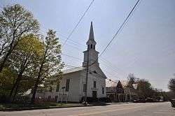
Saxtons River is an incorporated village in the town of Rockingham in Windham County, Vermont, United States. The population was 565 at the 2010 census. For over a hundred years, Saxtons River has been the home of Vermont Academy, an independent secondary school. Most of the village is a historic district listed on the National Register of Historic Places in 1986 as Saxtons River Village Historic District.[3]
Geography
According to the United States Census Bureau, the village has a total area of 0.5 square mile (1.3 km²), all land.
History
Saxtons River was first settled in 1783, but growth was extremely slow. A meeting house was built and the village cemetery established in 1810, and the first textile mill was opened at the Middle Falls (now officially named Saxtons River Falls) in 1815. The village bounds were determined by the town in 1820, and it was formally incorporated as a village in 1905, which is overseen by a Board of Trustees elected by registered voters of the Village. From 1900-1924, Rockingham’s two incorporated villages were linked by the Bellows Falls & Saxtons River Railroad, an electric train system. The company created Barbers Park, east of the Saxtons River about half way between the villages, to which summertime crowds took the trolleys to baseball games and amusement rides. Although Saxtons River village had a long history of industry (in particular successful textile operations, as well as saw mills, a grist mill, tannery, and distillery), much of it had failed by the 1920s. Located mostly inside the Village boundaries, and a strong influence on the character and economy of Saxtons River, is Vermont Academy, a private, co-educational high school founded in 1876. Vermont Academy established an annual Winter Carnival early in the 20th century, contributing to the creation of New England’s winter recreation culture. Student enrollment is around 230.[4] After a period of decline in the mid-20th century, many of the older buildings, such as the Saxtons River Inn, were restored and rehabilitated.[5]
Historic buildings include:
- Congregational Church (Main Street), now the Saxtons River Historical Society; 1836, 1871
- Saxtons River Village Building (Upper Main Street); c. 1860, c. 1970
- "Maple Grove," Smith-Bancroft-Neill House (Upper Main Street); c. 1830 and later
- Warner Block-Odd Fellows Building (Main Street), now the home of Main Street Arts; c. 1850
- Sabin-Bryant Block (Main and School Street); c. 1865
- Saxtons River Public School (School Street); 1915
- Saxtons River Inn (Main Street and Academy Avenue); 1903
- "The Beehive" (Academy Avenue); c. 1860
- Simonds Store - Saxtons River Village Market (Main Street and Academy Avenue); c. 1870
- Tin Shop or Saxwin Building (Main and Maple Streets); c. 1850
- Baptist Church (Main Street), now Christ's Church, UCC; 1840
- Fuller Hardware Store (Main Street); c. 1830
- Saxtons River Woolen Mill foundation (Maple Street); c. 1847 and later.
- Wool Pulling Shop (River Street); c. 1870
- Old South Meetinghouse site (Westminster Street)
- Saxtons River Cemetery (off Westminster Street)
- Tenney's Lumber Mill (off Westminster Street); 1870
- Thompson Gristmill (Westminster Street); c. 1850
Demographics
| Historical population | |||
|---|---|---|---|
| Census | Pop. | %± | |
| 1930 | 670 | — | |
| 1940 | 740 | 10.4% | |
| 1950 | 715 | −3.4% | |
| 1960 | 725 | 1.4% | |
| 1970 | 581 | −19.9% | |
| 1980 | 593 | 2.1% | |
| 1990 | 541 | −8.8% | |
| 2000 | 519 | −4.1% | |
| 2010 | 565 | 8.9% | |
| Est. 2016 | 545 | [6] | −3.5% |
| U.S. Decennial Census[7] | |||
As of the 2010 Census,[1] there were 565 people in 210 households in the village. The population density was 1,130 people per square mile (434.6/km²). The racial makeup of the village was 94.65% White, 1.6% Asian, 0.4% African American, 0.5% from other races, and 2.5% from two or more races. Hispanic or Latino of any race were 2.85% of the population.
In the village, the population was spread out with 29.3% under the age of 18, 8.4% from 18 to 24, 13.1% from 25 to 34, 40.5% from 35 to 64, and 14.2% who were 65 years of age or older. Median age was 37.6 years.
Notable people
- Humphrey B. Neill (1891-1977, aka "the Vermont Ruminator"), author of "The Art of Contrary Thinking" (1954), the timeless financial classic on contrarian investing.
- Horace Henry Baxter, prominent businessman and Adjutant General of the Vermont Militia during the American Civil War
- John Butler Smith, 44th Governor of New Hampshire
See also
| Wikimedia Commons has media related to Saxtons River, Vermont. |
References
- 1 2 "American FactFinder". United States Census Bureau. Retrieved 2008-01-31.
- ↑ "US Board on Geographic Names". United States Geological Survey. 2007-10-25. Retrieved 2008-01-31.
- ↑ National Park Service (2010-07-09). "National Register Information System". National Register of Historic Places. National Park Service.
- ↑ Saxtons River Village web site http://www.rockbf.org/index.asp?SEC=B4316549-8F7D-4EDF-ABB4-A92ACCD380F4&DE=206B9057-AEA5-4E58-B35B-C4444D788DB8&Type=B_BASIC Retrieved 7-29-17
- ↑ "NRHP nomination for Saxtons River Village Historic District". National Park Service. Retrieved 2015-12-29.
- ↑ "Population and Housing Unit Estimates". Retrieved June 9, 2017.
- ↑ "Census of Population and Housing". Census.gov. Retrieved June 4, 2015.
Municipalities and communities of Windham County, Vermont, United States | ||
|---|---|---|
| Towns | 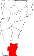 | |
| Villages | ||
| CDPs | ||
| Other communities | ||
| Footnotes | ‡ Disincorporated | |
| Topics | |
|---|---|
| Lists by states |
|
| Lists by insular areas | |
| Lists by associated states | |
| Other areas | |
| |
Coordinates: 43°08′16″N 72°30′35″W / 43.13778°N 72.50972°W