Sawyers Valley, Western Australia
| Sawyers Valley Perth, Western Australia | |||||||||||||||
|---|---|---|---|---|---|---|---|---|---|---|---|---|---|---|---|
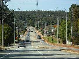 Great Eastern Highway in Sawyers Valley from the west | |||||||||||||||
 Sawyers Valley | |||||||||||||||
| Coordinates | 31°56′46″S 116°14′46″E / 31.946°S 116.246°ECoordinates: 31°56′46″S 116°14′46″E / 31.946°S 116.246°E | ||||||||||||||
| Population | 954 (2011 census)[1] | ||||||||||||||
| Postcode(s) | 6074 | ||||||||||||||
| LGA(s) | Shire of Mundaring | ||||||||||||||
| State electorate(s) | Darling Range | ||||||||||||||
| Federal Division(s) | Pearce | ||||||||||||||
| |||||||||||||||
Sawyers Valley is sited on the Great Eastern Highway about 40 kilometres from Perth, Western Australia in the Shire of Mundaring. The community began as a sawmill and railway siding to process timber from the forest surrounding the Helena River to the south. Local employment included forest and Goldfields Water Supply Scheme maintenance, small orchards, and the Midland Railway Workshops.
The Art Deco Sawyers Valley Tavern sits on the Highway opposite the Railway Reserve Heritage Trail.
Notes
- ↑ Australian Bureau of Statistics (31 October 2012). "Sawyers Valley (State Suburb)". 2011 Census QuickStats. Retrieved 2012-10-30.

References
External links
- http://www.vianet.net.au/~mdghobby/
- Sawyer's Valley on Geoscience Australia
- Mundaring and Hills Historical Society Website
This article is issued from
Wikipedia.
The text is licensed under Creative Commons - Attribution - Sharealike.
Additional terms may apply for the media files.