Sawiri, Lebanon
Name and location
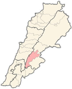
Sawiri or SAWAIRY or es-SAWAIRI (الصويري) is a town (village) in the eastern part of Lebanon. Its is located in the West Bekaa District near the Syrian borders, in governorate of Beqaa in the foothills of the eastern mountains.
Al-Masna (المصنع) is the main check point between the Lebanese & Syrian Borders and it is located in the territory of Sawiri.
Population
Sawiri's population is over 20,000 people with many of its inhabitants having immigrated to the United States, Brazil, Argentina, Venezuela, Canada and France in the 1900s. The major surnames or families in Sawiri are Janbein ,Amer, Berro, Balhis, El Smaily(Smaily or Smaili), Youssef, Abdel Razzak, Zeitoun, Shouman, Abou Nemry, Taleb, Shalaby, Abou Arab, Chebli, Tahan, Salha or Salim, Abdallah , Zrara and almoghubat.
Schools in Sawiri
Until the early 1990s, Sawiri had only two schools (Makased School and Sawiri Official School) educating up to Grade 9. At that time, the Sawiris used to continue their high school education in the neighbour towns of their village and then their university studies in Beirut. Sawiri nowadays has three big schools which allow the students to pass the Lebanese Brevet Examinations (Grade 9). Sawiri has one high school (Grade 12) which is funded by the Lebanese Ministry of Education. This high school is called: Sawiri Official High School. It started in 2003
Agriculture in Sawiri
Sawiri is an agriculture and service-oriented town. Most people own their land and come from a farming background. Sawiri produces lentils, figs, and Armenian cucumbers (mikthi). However, olive, Almond, nut and cherry trees have been grown rapidly as well as grape vines of all sorts in the last 3 decades. In the last 15 years, many "Sawiris" started growing up peanuts (Sterculia quadrifida) trees too.
Sawiri's Neighborhood
Sawiri is very close to Anjar, Lebanon and Baalbek where ancient history can be seen in the Roman and Umayyad ruins. It is also opposite the Tell Ain el Meten, a Heavy Neolithic archaeological site that was once used by the Qaraoun culture during the deforestation of Lebanon in prehistory. Some of the flints found at the site possibly date back to the Middle Paleolithic with other evidence of pottery from the Early Bronze Age and Middle Bronze Age.[1]
References
- 1 2 L. Copeland; P. Wescombe (1966). Inventory of Stone-Age Sites in Lebanon: North, South and East-Central Lebanon, p. 56. Impr. Catholique. Retrieved 29 August 2011.
- Frauberger, Heinrich: Die Akropolis von Baalbek (Keller : Frankfurt a. M., 1892. - 14, 22 S. : überw. Ill.) (pdf 24,6 MB)
External links
Coordinates: 33°41′13″N 35°54′17″E / 33.6869°N 35.9047°E
