Savignano sul Rubicone
| Savignano sul Rubicone | ||
|---|---|---|
| Comune | ||
| Comune di Savignano sul Rubicone | ||
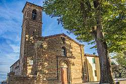 Pieve di San Giovanni in Compito | ||
| ||
 Savignano sul Rubicone Location of Savignano sul Rubicone in Italy | ||
| Coordinates: 44°6′N 12°24′E / 44.100°N 12.400°ECoordinates: 44°6′N 12°24′E / 44.100°N 12.400°E | ||
| Country | Italy | |
| Region | Emilia-Romagna | |
| Province | Forlì-Cesena (FC) | |
| Frazioni | Capanni, Fiumicino, Savignano a Mare | |
| Government | ||
| • Mayor | Elena Battistini | |
| Area | ||
| • Total | 23.2 km2 (9.0 sq mi) | |
| Elevation | 32 m (105 ft) | |
| Population (28 February 2009)[1] | ||
| • Total | 16,991 | |
| • Density | 730/km2 (1,900/sq mi) | |
| Demonym(s) | Savignanesi | |
| Time zone | UTC+1 (CET) | |
| • Summer (DST) | UTC+2 (CEST) | |
| Postal code | 47039 | |
| Dialing code | 0541 | |
| Website | Official website | |
Savignano sul Rubicone (Romagnol: Savgnèn) is a comune (municipality) in the Province of Forlì-Cesena in the Italian region Emilia-Romagna, located about 90 kilometres (56 mi) southeast of Bologna and about 30 kilometres (19 mi) southeast of Forlì.
The comune takes its name from the Rubicon, famous for Julius Caesar's historic crossing. A combination of natural and man-made changes caused the original Rubicon to change course repeatedly since then. For centuries the exact location of the original river was unknown. In 1991, the Fiumicino, a river which crosses Savignano sul Rubicone, was identified as the most likely location for the original Rubicon. Prior to that the region was called Savignano di Romagna.[2]
Twin towns


References
- ↑ All demographics and other statistics: Italian statistical institute Istat.
- ↑ Savignano sul Rubicone
External links
![]()
