Sauherad
| Sauherad kommune | |||
|---|---|---|---|
| Municipality | |||
| |||
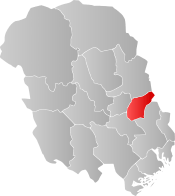 Sauherad within Telemark | |||
| Coordinates: 59°26′0″N 9°15′55″E / 59.43333°N 9.26528°ECoordinates: 59°26′0″N 9°15′55″E / 59.43333°N 9.26528°E | |||
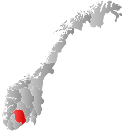
| Country | Norway | ||
| County | Telemark | ||
| District | Midt-Telemark | ||
| Administrative centre | Akkerhaugen | ||
| Government | |||
| • Mayor (2003) | Hans Sundsvalen (Ap) | ||
| Area | |||
| • Total | 321 km2 (124 sq mi) | ||
| • Land | 290 km2 (110 sq mi) | ||
| Area rank | #264 in Norway | ||
| Population (2004) | |||
| • Total | 4,351 | ||
| • Rank | #219 in Norway | ||
| • Density | 15/km2 (40/sq mi) | ||
| • Change (10 years) | -0.4% | ||
| Demonym(s) | Sauhering[1] | ||
| Time zone | UTC+01:00 (CET) | ||
| • Summer (DST) | UTC+02:00 (CEST) | ||
| ISO 3166 code | NO-0822 | ||
| Official language form | Neutral | ||
| Website |
www | ||
Sauherad is a municipality in Telemark county, Norway. It is part of the traditional region of Midt-Telemark. The administrative centre of the municipality is the village of Akkerhaugen. The municipality borders Kongsberg, Skien, Nome, Bø, and Notodden.
The parish of Søfde (later spelled Saude, then Sauherad) was established as a municipality on 1 January 1838 (see formannskapsdistrikt). The area of Luksefjell was transferred from Sauherad to Gjerpen in 1847.
General information
Name
The municipality (originally the parish) is named after the old Sauar farm (Old Norse: Sauðar), since the first church was built here. The name is the plural form of sauðr which means "spring" or "issue of water". The meaning of the combination Sauherad (Old Norse: Sauðaherað) is "the district (herað) of Sauðar". Prior to 1918, the name was written "Saude" or (before 1862) "Søfde".[2]
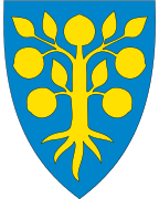
Coat-of-arms
The coat-of-arms is from modern times. They were granted in 1989. The arms show a gold-colored apple tree on a blue background. It was designed by Halvor Holtskog.
Transportation
- Railway - Both the Sørland Line and the Bratsberg Line run through Sauherad. The Bratsberg Line runs as part of the Sørland Line between Hjuksebø and Nordagutu. The Hjukse Bridge at Hjuksebø on the Bratsberg Line is Norway's tallest railway bridge at 65 metres (213 ft). Nordagutu Station is the only operating station left in Sauherad.
- Roads - Riksvei 36 and 360 goes through Sauherad, and so does Fylkesvei 44, 151, 551, 553, and 555. In 2008, all roads and streets got names, as one of the last municipalities in Norway.
Notable residents
- Myllarguten (Targjei Augundsson) (1801–1872), fiddler
- Dag-Eilev Fagermo (born 1967), football team trainer
- Lars Fykerud (1860–1902), fiddler
- Arne Haukvik (1926–2002), politician and founder of the Bislett Games
- Olav Haukvik (1928–1992), politician
- Liv Holtskog (born 1934), poet

Sauherad church
Sauherad church (Sauherad kirke) dates from the medieval era. The church was built between 1150 and 1250. The edifice is of stone and has 260 seats. The church is built in Romanesque style. On the ridge, in the middle of the gable roof, sits a turret. The church bells are from 1441. The altarpiece from 1663 is of Renaissance style. In 1781 the building was extended westward. In 1830 the church received a new interior. The frescoes in the nave were uncovered and restore during the 1940s and 1950s. [3]
Attractions
Events
- Sauheraddagane (since 1993)
- Kartfestivalen (Kart Festival, since 2005)
- Norsk Eplefest (Norwegian apple festival, since 2006)
Buildings
- Blæksås fortress (3-5th century)
- Bratningsborg fortress (3-5th century)
- Steinborg fortress (3-5th century)
- Evju Bygdetun (Museum)
- Nes stone church (12th century)
- Sauherad stone church (12th century)
Villages
- Akkerhaugen
- Gvarv
- Hjuksebø
- Holtsås
- Hørte
- Nordagutu
Sister cities
References
- ↑ "Navn på steder og personer: Innbyggjarnamn" (in Norwegian). Språkrådet. Retrieved 2015-12-01.
- ↑ Rygh, Oluf (1914). Norske gaardnavne: Bratsbergs amt (dokpro.uio.no) (in Norwegian) (7 ed.). Kristiania, Norge: W. C. Fabritius bogtrikkeri. pp. 214–215.
- ↑ "Sauherad kirke". kulturminnesok. Retrieved October 1, 2016.
- ↑ "Vennskapskommuner" (in Norwegian). Sauherad kommune. Archived from the original on 2011-07-21. Retrieved 2009-01-17.
External links
| Wikimedia Commons has media related to Sauherad. |
| Look up Sauherad in Wiktionary, the free dictionary. |
- Municipal fact sheet from Statistics Norway

| Øvre Telemark (Telemark) |
|  | ||||||
|---|---|---|---|---|---|---|---|---|
| Nedre Telemark (Grenland) |
| |||||||