Upper Telemark
| Upper Telemark | |
|---|---|
| District | |
.jpg) | |
 | |
| Country | Norway |
| Region | Austlandet |
| County | Telemark |
| Biggest city | Notodden |
| Area | |
| • Total | 12,404.94 km2 (4,789.57 sq mi) |
| Population (2015) | |
| • Total | 51,205 |
| • Density | 4.1/km2 (11/sq mi) |
| Demonym(s) |
Tele Teledøl Telemarking[1] |
Upper Telemark (Norwegian: Øvre Telemark) is a Norwegian region comprising the inland of the county Telemark. More than two thirds of the total area of Telemark, or above 10,000 square kilometres, belong to the traditional region of Upper Telemark. Conversely, Lower Telemark refers to the more densely populated, flatter coastal area of Grenland and traditionally also includes Central Telemark. Upper Telemark has a varied and often scenic landscape, with many hills, mountains, valleys and lakes.
Traditionally, the term Telemark only referred to this area, which also included Numedal. Upper Telemark is known for its folk traditions within music, clothing, handcrafts, food and architecture. The region is also distinctly marked by its dialect of Norwegian.
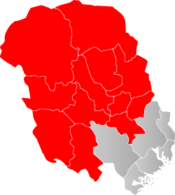
The district is also conventionally divided into Vest-Telemark and Aust-Telemark, with Vest-Telemark consisting of Vinje, Tokke, Seljord, Fyresdal, Kviteseid, Nissedal, and Aust-Telemark consisting of Hjartdal, Notodden and Tinn.
Whereas Lower Telemark was traditionally dominated by the burghers of the cities, Upper Telemark was for centuries dominated by a close-knit "aristocracy of officials" comprised by a handful of families which monopolized the state and church offices in the region, notably the families Paus, Blom, Ørn and Morland.[2]
Etymology
The Old Norse form of the name was Þelamörk or Þilamörk. The first element; Þilir was the name of the inhabitants, and is assumed to be connected with Þelli (pine). The last element mörk means forest or march.[3]
History
Administrative history
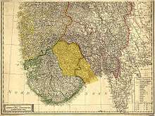
Traditionally, the term Telemark only referred to this area and Numedal.[4][5] In 1200, the current Upper Telemark and Grenland were merged into Skiens syssel, which later became Bratsbergs amt, and is the current county of Telemark.[4] Upper Telemark comprises a provostship in the state Church of Norway, Upper Telemark provostship (Norwegian: Øvre Telemark prosti), which now comprises 12 municipalities and more than 80% of Telemark (more than 12,000 square kilometres), making it one of the largest provostships in Norway. The provostship has existed since the middle ages, but was partitioned in two in 1838, before being reunified in 2015.[6] Upper Telemark has also been a judicial district (sorenskriveri).
The border between Upper Telemark and Grenland has long been discussed among philologists. In an old travel book about the county, A.L. Coll has written that the border is defined by the mountainous cleft, that is formed by the lakes Bolkesjø, Ørvella, Øverbø-moen, Seljordvatnet, Flåvatn and Fjågesund or Bjårvatn.[7]
References
- ↑ "Innbyggjarnamn". sprakradet.no.
- ↑ Jon Nygaard (2013). «...af stort est du kommen». Henrik Ibsen og Skien (p. 68 and p. 74). Senter for Ibsen-studier. ISBN 9788291540122
- ↑ Thorsnæs, Geir. "Telemark". snl.no.
- 1 2 Taraldlien 1933, p. 3.
- ↑ "Skatteparadiset Numedal". laagendalsposten.no. Archived from the original on 24 November 2015. (Subscription required (help)).
- ↑ "Øvre Telemark prosti ein realitet" (PDF). nome.kirken.no.
- ↑ Haukeland 2005, p. 9.
Literature
- Taraldlien, Bendik (1933). Telemark: gamal og ny tid. 2 (in Norwegian). Skien: I hovudkommisjon hjå Erik St. Nilssen.
- Haukeland, Per Ingvar (2005). Det sammensatte Telemark (in Norwegian). Bø: Telemarksforsking.
| Øvre Telemark (Telemark) |
|  | ||||||
|---|---|---|---|---|---|---|---|---|
| Nedre Telemark (Grenland) |
| |||||||