Sassafras, Victoria
| Sassafras Melbourne, Victoria | |||||||||||||||
|---|---|---|---|---|---|---|---|---|---|---|---|---|---|---|---|
 Sassafras township | |||||||||||||||
 Sassafras | |||||||||||||||
| Coordinates | 37°52′12″S 145°21′14″E / 37.87000°S 145.35389°ECoordinates: 37°52′12″S 145°21′14″E / 37.87000°S 145.35389°E | ||||||||||||||
| Population | 1,061 (2016)[1] | ||||||||||||||
| • Density | 322/km2 (833/sq mi) | ||||||||||||||
| Postcode(s) | 3787 | ||||||||||||||
| Area | 3.3 km2 (1.3 sq mi) | ||||||||||||||
| Location | |||||||||||||||
| LGA(s) | |||||||||||||||
| State electorate(s) | Monbulk | ||||||||||||||
| Federal Division(s) | La Trobe | ||||||||||||||
| |||||||||||||||
Sassafras is a locality and township within Greater Melbourne, beyond the Melbourne metropolitan area Urban Growth Boundary,[2] 43 km east of Melbourne's Central Business District, located within the City of Knox and Shire of Yarra Ranges local government areas. Sassafras recorded a population of 1,061 at the 2016 Census.
It is located at an altitude of approximately 500 metres, near the top of the ridgeline of the Dandenong Ranges, a few kilometres south of the highest peak of Mount Dandenong.
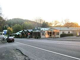
The area was named Sassafras Gully, after the trees which grew in the area. The land was opened to small scale farming in 1893 and a small township developed. The Post Office opened on 1 June 1901 and has always been known as Sassafras Gully.[3] In the early 1900s tourism began to increase and the township consequently grew. Today Sassafras is a tourist destination with several boutique stores including Devonshire tea outlets, antique shops and nurseries.
The area has had a history of bushfires, and areas near the town are known to have been burned out since the 1850s.[4]
Waterways
Sassafras is between the Yarra River Catchment and the Dandenong Creek. Sassafras creek is located to the east of the township while tributaries of the Dandenong Creek are West and North of the township. Both creeks provide important corridors which are both largely protect by parklands.
Sassafras Creek flows into Woori-Yallock Creek which eventually flows into the Yarra River next to the Warramate Nature Conservation Reserve. Sassafras Creek's Riparian Zone is almost entirely protected by public land, which in this case is Dandenong Ranges National Park.
Dandenong Creek flows straight into Port Phillip Bay at Patterson Lakes, but can be known as Patternson River near the entrance to Port Phillip Bay. Dandenong Creek has been channelled for several kilometers towards its mouth.
Natural environment
Sassafras has many exotic flora largely due to the fertile volcanic soils. Most private land contains exotic flora.
See also
- Shire of Sherbrooke - Sassafras was previously within this former local government area.
- Geography of the Yarra River
- Dandenong Creek Trail
References
- ↑ Australian Bureau of Statistics (27 June 2017). "Sassafras (State Suburb)". 2016 Census QuickStats. Retrieved 21 September 2017.

- ↑ Urban Growth Boundary map Archived 2011-04-05 at the Wayback Machine.
- ↑ Premier Postal History, Post Office List, archived from the original on 2008-05-10, retrieved 2008-04-11
- ↑ Wildfire History in the Dandenong Ranges, Olinda Rural Volunteer Fire Brigade (accessed 18 January 2008)
External links