Mount Evelyn, Victoria
| Mount Evelyn Melbourne, Victoria | |||||||||||||||
|---|---|---|---|---|---|---|---|---|---|---|---|---|---|---|---|
 Mount Evelyn | |||||||||||||||
| Coordinates | 37°46′59″S 145°23′06″E / 37.783°S 145.385°ECoordinates: 37°46′59″S 145°23′06″E / 37.783°S 145.385°E | ||||||||||||||
| Population | 9,374 (2011 census)[1] | ||||||||||||||
| Postcode(s) | 3796 | ||||||||||||||
| Elevation | 188 m (617 ft) | ||||||||||||||
| Location | |||||||||||||||
| LGA(s) | Shire of Yarra Ranges | ||||||||||||||
| State electorate(s) | Evelyn, Monbulk | ||||||||||||||
| Federal Division(s) | Casey | ||||||||||||||
| |||||||||||||||
Mount Evelyn is a suburb in Melbourne, Victoria, Australia, 37 km north-east of Melbourne's central business district. Its local government area is the Shire of Yarra Ranges. At the 2011 Census, Mount Evelyn had a population of 9,374 with an exact split of males and females.
History
Mount Evelyn nestles in a right-angled bend of the Olinda Creek, a large, permanent creek known originally as Running Creek. Different parts of the current Mount Evelyn area were first known as Olinda Vale, Billygoat Hill, McKillop/Valinda and South Wandin.
The Post Office opened on 15 February 1904 as Valinda (derived from Olinda Vale). The name was changed to Evelyn (the name of the county) in 1908, then to Mount Evelyn in 1913.[2] The town experienced a boom in the early 1930s due to the construction of the nearby Silvan Dam and Mount Evelyn Aqueduct, but was greatly affected by the depression of the same period once this project was completed in 1932.[3]
The railway line was closed in 1965, just before the area experienced rapid population growth in the 1970s and 1980s. Together with the nearby settlements of Belgrave, Monbulk and other towns, the region developed a tourism industry that persists to this day. The town's reserves were also incorporated into the larger Dandenong Ranges National Park in the southern part of the suburb.[3] Biannually, the Mt Evelyn Township Group run the Mt Evelyn Street Party, a 1950s styled event with food, workshops, activities, live performers, competitions and a fashion parade. The next instalment will be held on 29 October 2017.
Etymology
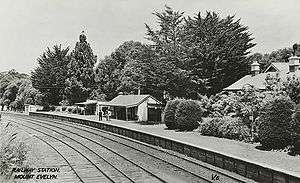
The (now closed) railway station, opened in 1901, was originally named 'Olinda Vale'. This was changed to 'Evelyn' after the county in which it is centrally placed, possibly as part of an attempt by the Victorian Railways to shorten names of stations. In 1919, the local progress association persuaded the Railways to add the "Mount" to encourage visitors to the healthy mountain area, which is the highest point on the railway (now the Lilydale to Warburton Rail Trail).[4]
Contrary to popular belief, the town was not named for the daughter of the Victorian Governor of the day. The origin of the name 'Evelyn' remains a mystery.[4]
Education
Mount Evelyn has five schools within its boundaries.
Parks and reserves
The Warburton Trail, a walking and cycling track, runs through Mount Evelyn. The trail runs between Lilydale and Warburton.
The Mount Evelyn Aqueduct Walk is another trail connecting Swansea Road to Hunter Road and the Mount Evelyn Forest (part of the Dandenong Ranges National Park).
Sport
The town has an Australian Rules football team competing in the Yarra Valley Mountain District Football League at Gary Martin Oval. The club was founded in 1931 as the Mount Evelyn Rovers.[5]
References
- ↑ Australian Bureau of Statistics (31 October 2012). "Mount Evelyn (State Suburb)". 2011 Census QuickStats. Retrieved 13 July 2016.

- ↑ Premier Postal History, Post Office List, retrieved 11 April 2008
- 1 2 "Mount Evelyn, Victoria". Monash Arts Online. Monash University. Archived from the original on 24 July 2005. Retrieved 13 July 2016.
- 1 2 "Naming of Mt Evelyn - an ongoing mystery". Mt Evelyn Community Website. Retrieved 2018-02-16.
- ↑ "150 years of AFL". Mount Evelyn Football and Netball Club History Project. Retrieved 13 July 2016.