Sarezzano
| Sarezzano | |
|---|---|
| Comune | |
| Comune di Sarezzano | |
 | |
 Sarezzano Location of Sarezzano in Italy | |
| Coordinates: 44°52′N 8°55′E / 44.867°N 8.917°ECoordinates: 44°52′N 8°55′E / 44.867°N 8.917°E | |
| Country | Italy |
| Region | Piedmont |
| Province | Province of Alessandria (AL) |
| Frazioni | Baracca, Cucco, Palazzina, Rocca Grue, San Ruffino, Sant'Innocenzo |
| Area | |
| • Total | 13.8 km2 (5.3 sq mi) |
| Elevation | 300 m (1,000 ft) |
| Population (Dec. 2004) | |
| • Total | 1,171 |
| • Density | 85/km2 (220/sq mi) |
| Demonym(s) | Sarezzanesi |
| Time zone | UTC+1 (CET) |
| • Summer (DST) | UTC+2 (CEST) |
| Postal code | 15050 |
| Dialing code | 0131 |
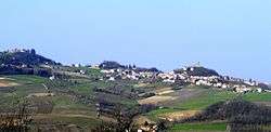
Sarezzano is a comune (municipality) in the Province of Alessandria in the Italian region Piedmont, located about 100 kilometres (62 mi) east of Turin and about 25 kilometres (16 mi) east of Alessandria. As of 31 December 2004, it had a population of 1,171 and an area of 13.8 square kilometres (5.3 sq mi).[1]
The municipality of Sarezzano contains the frazioni (subdivisions, mainly villages and hamlets) Baracca, Cucco, Palazzina, Rocca Grue, San Ruffino, and Sant'Innocenzo.
Sarezzano borders the following municipalities: Berzano di Tortona, Cerreto Grue, Monleale, Montegioco, Tortona, Viguzzolo, and Villaromagnano.
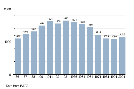
Demographic evolution
References

This article is issued from
Wikipedia.
The text is licensed under Creative Commons - Attribution - Sharealike.
Additional terms may apply for the media files.