San Salvatore Monferrato
| San Salvatore Monferrato | ||
|---|---|---|
| Comune | ||
| Comune di San Salvatore Monferrato | ||
 | ||
| ||
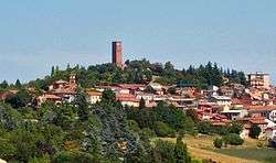
 San Salvatore Monferrato Location of San Salvatore Monferrato in Italy | ||
| Coordinates: 44°59′42″N 8°34′1″E / 44.99500°N 8.56694°E | ||
| Country | Italy | |
| Region | Piedmont | |
| Province | Alessandria (AL) | |
| Frazioni | Fosseto, Frescondino, Piazzolo, Salcido, Valdolenga, Valparolo | |
| Government | ||
| • Mayor | Enrico Beccaria | |
| Area | ||
| • Total | 31.65 km2 (12.22 sq mi) | |
| Elevation | 205 m (673 ft) | |
| Population (30 November 2017[1]) | ||
| • Total | 4,261 | |
| • Density | 130/km2 (350/sq mi) | |
| Demonym(s) | Sansalvatoresi | |
| Time zone | UTC+1 (CET) | |
| • Summer (DST) | UTC+2 (CEST) | |
| Postal code | 15046 | |
| Dialing code | 0131 | |

San Salvatore Monferrato is a comune (municipality) in the Province of Alessandria in the Italian region Piedmont, located about 70 kilometres (43 mi) east of Turin and about 10 kilometres (6 mi) northwest of Alessandria.
Main sights
The tower of the Paleologi was erected for Theodore II, Marquess of Montferrat.
Other sights include the 16th century churches of San Martino e San Siro. the communal cemetery of the town is home to the grave of Paolo Provera, surnamed Tantasà, an example of outsider art.
People
- Iginio Ugo Tarchetti (1839–1869), a novelist, also poet and journalist, and part of the Milanese Scapigliatura.
- Paolo Provera (Tantasà) (1850–1930), an outsider artist.
Eugenio "Gene" Guglielmi (1947–), a beat folksinger.
References
| Wikimedia Commons has media related to San Salvatore Monferrato. |

This article is issued from
Wikipedia.
The text is licensed under Creative Commons - Attribution - Sharealike.
Additional terms may apply for the media files.