Fresonara
| Fresonara | ||
|---|---|---|
| Comune | ||
| Comune di Fresonara | ||
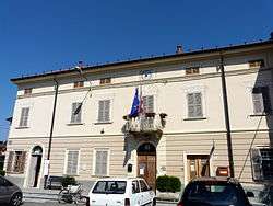 Town hall. | ||
| ||
 Fresonara Location of Fresonara in Italy | ||
| Coordinates: 44°46′N 8°41′E / 44.767°N 8.683°ECoordinates: 44°46′N 8°41′E / 44.767°N 8.683°E | ||
| Country | Italy | |
| Region | Piedmont | |
| Province | Alessandria (AL) | |
| Government | ||
| • Mayor | Massimo Bisio | |
| Area | ||
| • Total | 6.93 km2 (2.68 sq mi) | |
| Elevation | 143 m (469 ft) | |
| Population (31 August 2017)[1] | ||
| • Total | 697 | |
| • Density | 100/km2 (260/sq mi) | |
| Demonym(s) | Fresonaresi | |
| Time zone | UTC+1 (CET) | |
| • Summer (DST) | UTC+2 (CEST) | |
| Postal code | 15060 | |
| Dialing code | 0143 | |
| Saint day | September 8 | |
| Website | Official website | |
Fresonara (Piedmontese: Fërsnèira) is a comune (municipality) in the province of Alessandria in the Italian region Piedmont, located about 80 kilometres (50 mi) southeast of Turin and about 15 kilometres (9 mi) southeast of Alessandria.
Fresonara borders the following municipalities: Basaluzzo, Bosco Marengo, and Predosa.
In 1404 it was destroyed by Facino Cane. It was annexed to the possessione of the House of Savoy in the 18th century.
References

This article is issued from
Wikipedia.
The text is licensed under Creative Commons - Attribution - Sharealike.
Additional terms may apply for the media files.