Sarankot
| Sarangkot सराङकोट | |
|---|---|
| Subdivision of Pokhara | |
 View from Sarangkot to Annapurna Conservation Area | |
 Sarangkot Location in Nepal | |
| Coordinates: 28°14′30″N 83°58′0″E / 28.24167°N 83.96667°ECoordinates: 28°14′30″N 83°58′0″E / 28.24167°N 83.96667°E | |
| Country |
|
| Zone | Gandaki Zone |
| District | Kaski District |
| Population (1991) | |
| • Total | 5,060 |
| Time zone | UTC+5:45 (NST) |
| Area code(s) | 061 |
Sarangkot is a former Village Development Committee west of Pokhara in Kaski District Gandaki Zone. In 2015, it was annexed to Pokhara 26. At the time of the 1991 Nepal census it had a total population of 5,060 with 1,010 individual households.[1]
The village is located on Sarangkot mountain at an altitude of 1600m and is renowned for its panoramic Himalayan views Dhaulagiri, Annapurna and Manaslu as well as down on the city of Pokhara and Phewa lake. In recent years, Sarangkot has become a hotspot for paragliding.
Media
To promote local culture, Sarankot has one FM radio station Radio Sarangkot - 104.6 MHz Which is a Community radio Station.
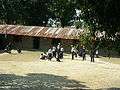 Sarankot school
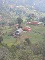
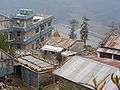
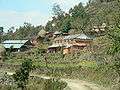
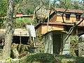 Sarankot village
 Traditional houses
References
- ↑ "Nepal Census 2001". Nepal's Village Development Committees. Digital Himalaya. Retrieved September 30, 2008.
External links
| Wikimedia Commons has media related to Sarankot. |
Headquarters: Pokhara | ||
| Metropolitan cities | 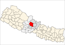 | |
| Rural municipalities |
| |
| Former VDCs |
| |
| Villages | ||
This article is issued from
Wikipedia.
The text is licensed under Creative Commons - Attribution - Sharealike.
Additional terms may apply for the media files.