Santee Canal
|
Santee Canal | |
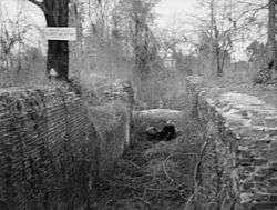 Frierson's Lock on the Old Santee Canal | |
  | |
| Location | Berkeley County, South Carolina, USA |
|---|---|
| Nearest city | Moncks Corner, South Carolina |
| Coordinates | 33°25′36″N 80°6′7″W / 33.42667°N 80.10194°WCoordinates: 33°25′36″N 80°6′7″W / 33.42667°N 80.10194°W |
| Area | 50 acres (20 ha) |
| Built | 1793-1800 |
| Architect | Col. John Christian Senf |
| NRHP reference # | 82003833[1] |
| Added to NRHP | August 11, 1982 |
The Santee Canal was one of the earliest canals built in the United States. It was built to provide a direct water route between Charleston and Columbia, the new South Carolina state capital.[2][3] It was named to the National Register of Historic Places in 1982.
History
In 1786, the South Carolina General Assembly chartered a company to construct and maintain the inland canal linking the Cooper River near Charleston, with the Santee River. The Santee River connects to the Congaree River and the City of Columbia. Construction started in 1793 under the direction of Engineer Col. John Christian Senf. It opened in 1800.
It was 22 miles (35 km) long. It had two double locks and eight single locks. Its width was 35 feet (11 m) at the water's surface and 20 feet (6.1 m) at the bottom. Its depth was 4 feet (1.2 m).
Due to low traffic, poor construction, and droughts, the canal was not a financial success. The construction of railroads sealed its fate. It lost its state charter in 1853. It was not used after 1865. Much of it was flooded by the construction of Lake Moultrie.[4][5]
Additional pictures and information are available from the Historic American Buildings Survey at the Library of Congress.[6]
Park
Old Santee Canal Park is located in Monks Corner, South Carolina. The park is situated at Stony Landing, the former southernmost section of the canal.[7]
References
- ↑ National Park Service (2010-07-09). "National Register Information System". National Register of Historic Places. National Park Service.
- ↑ Wylie, Suzanne Pickens; David Chamberlain (December 28, 1981). "Santee Canal" (pdf). National Register of Historic Places - Nomination and Inventory. Retrieved 9 June 2012.
- ↑ "Santee Canal, Berkeley County (Moncks Corner to Pineville vicinities)". National Register Properties in South Carolina. South Carolina Department of Archives and History. Retrieved 9 June 2012.
- ↑ Edgar, Walter, ed. (2006). The South Carolina Encyclopedia. University of South Carolina Press. p. 838. ISBN 1-57003-598-9.
- ↑ "Old Santee Canal Park". Retrieved 8 December 2016.
Today, most of the Santee Canal lies beneath Lake Moultrie, but visible portions remain where boats entered from the Santee River and at Biggin Creek, where it joined the headwaters of the Cooper River.
- ↑ Historic American Buildings Survey (HABS) No. SC-240, "Santee Canal Structures (Area Survey), Moncks Corner, Berkeley County, SC", 4 photos
- ↑ "Canal History".
External links
- Historic American Buildings Survey (HABS) No. SC-240, "Santee Canal Structures (Area Survey), Moncks Corner, Berkeley County, SC", 4 photos
- Porcher, F. A. 1809-1888. (1903). The history of the Santee Canal. Charleston, S.C.: South Carolina Historical Society. Accessed June 12, 2018.
See also
| Topics |  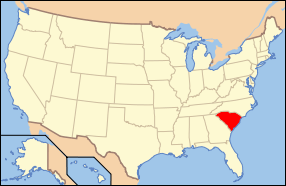 | |
|---|---|---|
| Lists by county |
| |
| Lists by city | ||
| Other lists | ||