Sankt Leonhard im Pitztal
| St. Leonhard im Pitztal | ||
|---|---|---|
 | ||
| ||
 St. Leonhard im Pitztal Location within Austria
Location in the district
| ||
| Coordinates: 47°04′00″N 10°50′00″E / 47.06667°N 10.83333°ECoordinates: 47°04′00″N 10°50′00″E / 47.06667°N 10.83333°E | ||
| Country | Austria | |
| State | Tyrol | |
| District | Imst | |
| Government | ||
| • Mayor | Rupert Hosp | |
| Area | ||
| • Total | 223.4 km2 (86.3 sq mi) | |
| Elevation | 1,366 m (4,482 ft) | |
| Population (1 January 2016)[1] | ||
| • Total | 1,393 | |
| • Density | 6.2/km2 (16/sq mi) | |
| Time zone | UTC+1 (CET) | |
| • Summer (DST) | UTC+2 (CEST) | |
| Postal code | 6481 | |
| Area code | 05413 | |
| Vehicle registration | IM | |
| Website | www.st-leonhard.tirol.gv.at | |


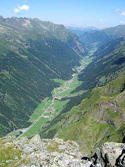
Sankt Leonhard im Pitztal is a municipality in the Imst district, located 20 kilometres (12 mi) south of Imst on the upper course of the Pitze River in western Austria. The village covers a large area and has a length of around 25 kilometres (16 mi). It is one of the biggest communities of Tyrol by area.
The climate is severe because of mountain flanks. The area was founded around 1300, and its main source of income is tourism.
Population
| Historical population | ||
|---|---|---|
| Year | Pop. | ±% |
| 1869 | 1,147 | — |
| 1880 | 1,057 | −7.8% |
| 1890 | 1,039 | −1.7% |
| 1900 | 986 | −5.1% |
| 1910 | 1,032 | +4.7% |
| 1923 | 932 | −9.7% |
| 1934 | 983 | +5.5% |
| 1939 | 989 | +0.6% |
| 1951 | 1,042 | +5.4% |
| 1961 | 1,150 | +10.4% |
| 1971 | 1,224 | +6.4% |
| 1981 | 1,299 | +6.1% |
| 1991 | 1,404 | +8.1% |
| 2001 | 1,472 | +4.8% |
| 2011 | 1,463 | −0.6% |
References
- ↑ Statistik Austria - Bevölkerung zu Jahresbeginn 2002-2016 nach Gemeinden (Gebietsstand 1.1.2016) for St. Leonhard im Pitztal.
External links
| Wikimedia Commons has media related to St. Leonhard im Pitztal. |
- www.st-leonhard.tirol.gv.at - city website
This article is issued from
Wikipedia.
The text is licensed under Creative Commons - Attribution - Sharealike.
Additional terms may apply for the media files.