Sankt Gotthard im Mühlkreis
| Sankt Gotthard im Mühlkreis | ||
|---|---|---|
 | ||
| ||
 Sankt Gotthard im Mühlkreis Location within Austria | ||
| Coordinates: 48°22′10″N 14°07′02″E / 48.36944°N 14.11722°ECoordinates: 48°22′10″N 14°07′02″E / 48.36944°N 14.11722°E | ||
| Country | Austria | |
| State | Upper Austria | |
| District | Urfahr-Umgebung | |
| Government | ||
| • Mayor | Johannes Rechberger (ÖVP) | |
| Area | ||
| • Total | 12 km2 (5 sq mi) | |
| Elevation | 473 m (1,552 ft) | |
| Population (14 June 2016)[1] | ||
| • Total | 1,289 | |
| • Density | 110/km2 (280/sq mi) | |
| Time zone | UTC+1 (CET) | |
| • Summer (DST) | UTC+2 (CEST) | |
| Postal code | 4112 | |
| Area codes | 0 72 34 | |
| Vehicle registration | UU | |
| Website | www.sanktgotthard.at | |

Sankt Gotthard im Mühlkreis is a municipality in the district of Urfahr-Umgebung in Upper Austria, Austria.
Attractions include Schloss Eschelberg, a stately home built in 1596, and the ruined 13th century Rottenegg Castle.[2]
Villages
The municipality contains the following villages:
- Eschelberg
- Grasbach
- Haselwies
- Maierleiten
- Mühlholz
- Oberstraß
- Rottenegg
Population
| Historical population | ||
|---|---|---|
| Year | Pop. | ±% |
| 1869 | 779 | — |
| 1890 | 790 | +1.4% |
| 1910 | 756 | −4.3% |
| 1923 | 761 | +0.7% |
| 1934 | 742 | −2.5% |
| 1939 | 688 | −7.3% |
| 1951 | 966 | +40.4% |
| 1971 | 975 | +0.9% |
| 1991 | 1,125 | +15.4% |
| 2001 | 1,299 | +15.5% |
| 2007 | 1,314 | +1.2% |
Gallery
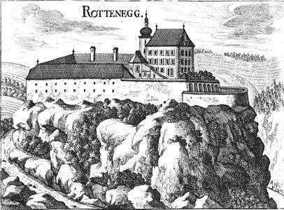 Rottenegg Castle, now ruined
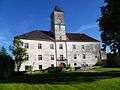 Schloss Eschelberg, built in 1596
 Schloss Eschelberg forest house
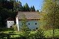 Medieval mill house
 Former prison
References
- ↑ Statistik Austria - Bevölkerung zu Jahresbeginn 2002-2016 nach Gemeinden, Erstellt am 14.06.2016 (Last accessed 13.12.2016) for Sankt Gotthard im Mühlkreis.
- ↑ "Oberösterreich unbewegliche und archäologische Denkmale unter Denkmalschutz" (PDF). Bundesdenkmalamtes Österreich. 28 June 2013. p. 136.
| Wikimedia Commons has media related to Sankt Gotthard im Mühlkreis. |
This article is issued from
Wikipedia.
The text is licensed under Creative Commons - Attribution - Sharealike.
Additional terms may apply for the media files.