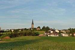
Bad Leonfelden
| Bad Leonfelden | ||
|---|---|---|
 | ||
| ||
 Bad Leonfelden Location within Austria | ||
| Coordinates: 48°31′31″N 14°17′36″E / 48.52528°N 14.29333°ECoordinates: 48°31′31″N 14°17′36″E / 48.52528°N 14.29333°E | ||
| Country | Austria | |
| State | Upper Austria | |
| District | Urfahr-Umgebung | |
| Government | ||
| • Mayor | Alfred Hartl (ÖVP) | |
| Area | ||
| • Total | 40 km2 (20 sq mi) | |
| Elevation | 750 m (2,460 ft) | |
| Population (14 June 2016)[1] | ||
| • Total | 4,210 | |
| • Density | 110/km2 (270/sq mi) | |
| Time zone | UTC+1 (CET) | |
| • Summer (DST) | UTC+2 (CEST) | |
| Postal code | 4190 | |
| Area code | 07213 | |
| Vehicle registration | UU | |
| Website | www.bad-leonfelden.ooe.gv.at | |
Bad Leonfelden is a municipality in the district of Urfahr-Umgebung in the Austrian state of Upper Austria. Steven Beller, author of A Concise History of Austria,[2] who has family links to Bad Leonfelden, cites episodes from the town's history from its foundation in 1292 to the 21st century, to demonstrate the impact of historical and political events on the local life in Austria's rural provinces. The Jugendstil mosaicist Leopold Forstner was born there.[3]
Population
| Historical population | ||
|---|---|---|
| Year | Pop. | ±% |
| 1869 | 2,805 | — |
| 1880 | 2,790 | −0.5% |
| 1890 | 2,894 | +3.7% |
| 1900 | 2,795 | −3.4% |
| 1910 | 2,698 | −3.5% |
| 1923 | 2,609 | −3.3% |
| 1934 | 2,466 | −5.5% |
| 1939 | 2,730 | +10.7% |
| 1951 | 2,617 | −4.1% |
| 1961 | 2,546 | −2.7% |
| 1971 | 2,712 | +6.5% |
| 1981 | 3,048 | +12.4% |
| 1991 | 3,419 | +12.2% |
| 2001 | 3,847 | +12.5% |
| 2011 | 4,064 | +5.6% |
References
- ↑ Statistik Austria - Bevölkerung zu Jahresbeginn 2002-2016 nach Gemeinden, Erstellt am 14.06.2016 (Last accessed 13.12.2016) for Bad Leonfelden.
- ↑ Beller, Steven, A Concise history of Austria (Cambridge: Cambridge University Press, 2006).
- ↑ "Neues "Kulturviertel" am Leonfeldner Stadtplatz". www.nachrichten.at. Retrieved 15 June 2016.
| Wikimedia Commons has media related to Bad Leonfelden. |
| Authority control |
|---|
This article is issued from
Wikipedia.
The text is licensed under Creative Commons - Attribution - Sharealike.
Additional terms may apply for the media files.