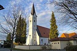
Goldwörth
| Goldwörth | ||
|---|---|---|
 | ||
| ||
 Goldwörth Location within Austria | ||
| Coordinates: 48°20′39″N 14°06′00″E / 48.34417°N 14.10000°ECoordinates: 48°20′39″N 14°06′00″E / 48.34417°N 14.10000°E | ||
| Country | Austria | |
| State | Upper Austria | |
| District | Urfahr-Umgebung | |
| Government | ||
| • Mayor | Helmut Außerwöger (ÖVP) | |
| Area | ||
| • Total | 11 km2 (4 sq mi) | |
| Elevation | 262 m (860 ft) | |
| Population (14 June 2016)[1] | ||
| • Total | 894 | |
| • Density | 81/km2 (210/sq mi) | |
| Time zone | UTC+1 (CET) | |
| • Summer (DST) | UTC+2 (CEST) | |
| Postal code | 4100 | |
| Area codes | 0 72 34 | |
| Vehicle registration | UU | |
| Website | www.goldwoerth.at | |
Goldwörth is a municipality in the district of Urfahr-Umgebung in the Austrian state of Upper Austria.
Geography
Goldwörth lies in the upper Mühlviertel.
References
| Wikimedia Commons has media related to Goldwörth. |
This article is issued from
Wikipedia.
The text is licensed under Creative Commons - Attribution - Sharealike.
Additional terms may apply for the media files.