Sanggau Regency
| Sanggau Regency Kabupaten Sanggau | ||
|---|---|---|
| Regency | ||
  From top to bottom: Regent Office Building and State Court Building | ||
| ||
| Nickname(s): Bumi Daranante | ||
| Motto(s): Sanggau Permai | ||
 Location within West Kalimantan | ||
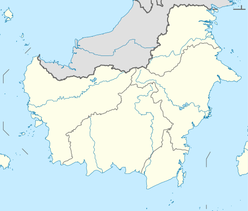 Sanggau Regency Location in Kalimantan and Indonesia  Sanggau Regency Sanggau Regency (Indonesia) | ||
| Coordinates: 0°07′10″N 110°35′20″E / 0.11944°N 110.58889°ECoordinates: 0°07′10″N 110°35′20″E / 0.11944°N 110.58889°E | ||
| Country | Indonesia | |
| Province | West Kalimantan | |
| Capital | Sanggau | |
| Government | ||
| • Regent | Paolus Hadi | |
| • Vice Regent | Yohanes Ontot | |
| Area | ||
| • Total | 12,857.80 km2 (4,964.42 sq mi) | |
| Elevation | 200-400 m (1,312 ft) | |
| Population (2014) | ||
| • Total | 422,448 | |
| • Density | 33/km2 (85/sq mi) | |
| Time zone | UTC+7 (WIB) | |
| Postcode | 785xx | |
| Area code | (+62) 564 | |
| Vehicle registration | KB | |
| Website |
sanggau | |

Sanggau Regency (Chinese: 桑高; Hakka: Sîang-ngau) is a regency in West Kalimantan province of Indonesia. It is situated in the north-central part of the province, with an area (since the separation of the former eastern part of the regency in 2003 to create Sekadau Regency) of 12,857.80 km² and a population of 408,468 at the 2010 Census;[1] the latest official estimate (for January 2014) is 422,448. Alongside with Landak Regency, Sekadau Regency, and Sintang Regency, Sanggau is one of the four West Kalimantan regencies that are predominantly Catholic.
Administrative Districts

Sanggau Regency consists of fifteen districts (kecamatan), tabulated below with their populations at the 2010 Census[2] and their administrative centres:
| District | Area (km²) | Population 2010 Census | Administrative Centre |
|---|---|---|---|
| Toba | 1,127.20 | 11,954 | Teraju |
| Meliau | 1,495.70 | 46,150 | Meliau |
| Kapuas | 1,382.00 | 78,768 | Sanggau |
| Mukok | 501.00 | 18,256 | Kedukul |
| Jangkang | 1,589.20 | 26,674 | Balai Sebut |
| Bonti | 1,121.80 | 20,281 | Bonti |
| Parindu | 593.90 | 32,426 | Pusat Damai |
| Tayan Hilir | 1,050.50 | 29,990 | Tayan |
| Balai | 395.60 | 22,279 | Batang Terang |
| Tayan Hulu | 719.20 | 31,080 | Sosok |
| Kembayan | 610.80 | 25,796 | Kembayan |
| Beduwai | 435.00 | 10,744 | Beduwai |
| Noyan | 487.90 | 9,873 | Noyan |
| Sekayam | 841.01 | 29,639 | Balai Karangan |
| Entikong | 506.89 | 14,558 | Entikong |
| Totals | 12,857.80 | 408,468 |
Ethnical population statistics
- Dayak Bidayuh, in kecamatan (district) of Kembayan, Noyan, Sekayam and Jangkang
- Dayak Mali, in kecamatan (district) of Balai, Tayan Hulu, Tayan Hilir, Toba, Simpang dua (Ketapang), Meliau, Noyan.
- Dayak Desa, in kecamatan (district) of Toba.
- Dayak Ribun, in kecamatan (district) of Tayan Hulu, Meliau and Parindu.
- Dayak Iban, in the area around Indonesia-Malaysia border.
- Chinese, spread across in the regency.
- Malay, spread across in the regency.
- Others: Javanese, Sunda, Batak, Minang, and Bugis.
Places
- Riam Macan
- Pancur Aji
- Sipatn Lotup
- Penyeladi
- Laverna
Transportation
Land
Roads in Sanggau are pretty narrow and not well paved due to the limitation of government budget. In certain areas, the road is in pretty poor condition with many holes and slightly muddy along the road.
Water
There are two main rivers flowing through Sanggau, they are Kapuas river and Sekayam river. Water transportation remains the popular choice amongst the people live in small villages / remote areas which are not accessible by road. In addition, it is also used for distributing goods such as foods, medicines, etc. The following are the popular transports:
Air
There is no airport in Sanggau regency, hence the nearest gateway are Supadio Airport (Pontianak) and Kuching International Airport(Sarawak, Malaysia).
See also
References
External links
- Official Sanggau Regency
- Sanggau on Maplandia
- Sanggau on VirtualTourist
- Diocese of Sanggau
- http://www.catholic-hierarchy.org/diocese/dsngg.html
Regencies and cities of West Kalimantan | ||
|---|---|---|
Capital: Pontianak | ||
| Regencies | ||
| Cities | ||