Sintang Regency
| Sintang Regency Kabupaten Sintang | ||
|---|---|---|
| Regency | ||
| ||
 Location within West Kalimantan | ||
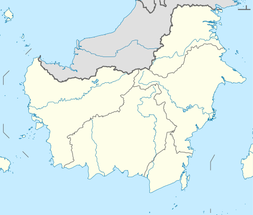 Sintang Regency Location in Kalimantan and Indonesia  Sintang Regency Sintang Regency (Indonesia) | ||
| Coordinates: 0°04′05″N 111°29′53″E / 0.06806°N 111.49806°E | ||
| Country | Indonesia | |
| Province | West Kalimantan | |
| Capital | Sintang | |
| Government | ||
| • Regent | Jarot Winarno | |
| • Vice Regent | Askiman | |
| Area | ||
| • Total | 21,638.20 km2 (8,354.56 sq mi) | |
| Population (2014) | ||
| • Total | 377,243 | |
| • Density | 17/km2 (45/sq mi) | |
| Time zone | UTC+7 (IWST) | |
| Area code | (+62) 565 | |
| Website |
sintang | |
Sintang Regency (Chinese: 新当) is a regency of West Kalimantan province of Indonesia. It covers an area of 21,638.2 km2, and had a population of 364,759 at the 2010 Census;[1] the latest official estimate (for January 2014) is 377,243. The principal town lies at Sintang.
Administrative Districts
Sintang Regency consists of fourteen districts (kecamatan), tabulated below with their populations at the 2010 Census:[2]
| District | Population 2010 Census |
|---|---|
| Serawai | 21,922 |
| Ambalau | 12,867 |
| Kayan Hulu (Upper Kayan) | 21,854 |
| Sepauk | 46,407 |
| Tempunak | 26,860 |
| Sungai Tebelian | 29,144 |
| Sintang | 59,410 |
| Dedai | 27,573 |
| Kayan Hilir (Lower Kayan) | 24,423 |
| Kelam Permai | 15,276 |
| Binjai Hulu (Upper Binjai) | 11,332 |
| Ketungau Hilir (Lower Ketungau) | 20,567 |
| Ketungau Tengah (Central Ketungau) | 27,421 |
| Ketungau Hulu (Upper Ketungau) | 19,703 |
| Totals | 364,759 |
Baning Nature Tourist Park
The park is tropical nature forest located in city center, the only one in Indonesia which declared in 1999.[3]
References
- ↑ Biro Pusat Statistik, Jakarta, 2011.
- ↑ Biro Pusat Statistik, Jakarta, 2011.
- ↑ "Berwisata di Hutan Tengah Kota". January 17, 2012.
Regencies and cities of West Kalimantan | ||
|---|---|---|
Capital: Pontianak | ||
| Regencies | ||
| Cities | ||
Coordinates: 0°04′05″N 111°29′53″E / 0.06806°N 111.49806°E
This article is issued from
Wikipedia.
The text is licensed under Creative Commons - Attribution - Sharealike.
Additional terms may apply for the media files.