Sand Hill River
| Sand Hill River | |
 | |
| Country | United States |
|---|---|
| State | Minnesota |
| Region | Northwestern Minnesota |
| City | Rindal, Fertile, Climax |
| Source | Sand Hill Lake |
| - location | Near Fertile, MN |
| Mouth | Red River of the North |
| - location | Climax, MN |
| Length | 101 mi (163 km) |
| Basin | 475 sq mi (1,230 km2) |
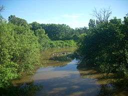
The Sand Hill River is a 101-mile-long (163 km)[1] tributary of the Red River of the North in northwestern Minnesota in the United States.[2] Via the Red River, Lake Winnipeg, and the Nelson River, it is part of the watershed of Hudson Bay, and drains an area of 475 square miles (1,230 km2).
Sand Hill River was named for the sand dunes near end of its course.[3]
Course
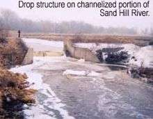
The Sand Hill River flows generally west from its source, Sand Hill Lake, near the town of Fosston in Polk County, dipping south through Mahnomen County and Norman County before returning to Polk County and passing the towns of Rindal, Fertile, and Climax. It flows into the Red River of the North 2 miles (3 km) west of Climax.
See also
References
- ↑ U.S. Geological Survey. National Hydrography Dataset high-resolution flowline data. The National Map, accessed June 8, 2011
- ↑ U.S. Geological Survey Geographic Names Information System: Sand Hill River
- ↑ Upham, Warren (1920). Minnesota Geographic Names: Their Origin and Historic Significance. Minnesota Historical Society. p. 324.
Sources
- "Sand Hill River Watershed District". Retrieved 2007-05-23.
Coordinates: 47°35′55″N 96°51′21″W / 47.59861°N 96.85583°W