Sand Hill, Greene County, Mississippi
| Sand Hill, Mississippi | |
|---|---|
| Unincorporated community | |
 Sand Hill  Sand Hill | |
| Coordinates: 31°21′N 88°46′W / 31.350°N 88.767°WCoordinates: 31°21′N 88°46′W / 31.350°N 88.767°W | |
| Country | United States |
| State | Mississippi |
| County | Greene |
| Elevation | 315 ft (96 m) |
| Time zone | UTC-6 (Central (CST)) |
| • Summer (DST) | UTC-5 (CDT) |
| Area code(s) | 601 & 769 |
| GNIS feature ID | 677340[1] |
Sand Hill is an unincorporated community in Greene County, Mississippi, United States. Sand Hill is located at the junction of Mississippi Highway 42 and Mississippi Highway 63 18 miles (29 km) northwest of Leakesville.[2]
References
- ↑ "Sand Hill". Geographic Names Information System. United States Geological Survey.
- ↑ Greene County, Mississippi General Highway Map (PDF) (Map). Mississippi Department of Transportation. 2010. Retrieved October 29, 2012.
Municipalities and communities of Greene County, Mississippi, United States | ||
|---|---|---|
| Cities | 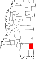 | |
| Unincorporated communities | ||
| Footnotes | ‡This populated place also has portions in an adjacent county or counties | |
This article is issued from
Wikipedia.
The text is licensed under Creative Commons - Attribution - Sharealike.
Additional terms may apply for the media files.