San Vito Chietino
| San Vito Chietino | ||
|---|---|---|
| Comune | ||
| Comune di San Vito Chietino | ||
 | ||
| ||
 San Vito Chietino Location of San Vito Chietino in Italy | ||
| Coordinates: 42°18′N 14°27′E / 42.300°N 14.450°E | ||
| Country | Italy | |
| Region | Abruzzo | |
| Province | Chieti (CH) | |
| Frazioni | Anticaglia, Balsamate, Bufara, Castellana, Cese, Cintioni, Colle Capuano, Foresta, Mancini, Melogranato, Murata Alta, Murata Bassa, Paolini, Passo Tucci, Pontoni, Portelle, Quercia del Corvo, Rapanice, Renazzo, San Fino, San Rocco Vecchio, Sant'Apollinare, Sciutico, Strutte, Valle Ienno, Vicende | |
| Government | ||
| • Mayor | Rocco Catenaro | |
| Area | ||
| • Total | 16 km2 (6 sq mi) | |
| Elevation | 122 m (400 ft) | |
| Population (31 December 2009[1]) | ||
| • Total | 5,326 | |
| • Density | 330/km2 (860/sq mi) | |
| Demonym(s) | Sanvitesi | |
| Time zone | UTC+1 (CET) | |
| • Summer (DST) | UTC+2 (CEST) | |
| Postal code | 66038 | |
| Dialing code | 0872 | |
| Patron saint | St. Vitus | |
| Saint day | 15 June | |
| Website | Official website | |

San Vito Chietino is a town and comune in the province of Chieti in the Abruzzo region of central Italy.
Geography
The town is bordered by Frisa, Lanciano, Ortona, Rocca San Giovanni, Treglio and Fossacesia.
Economy
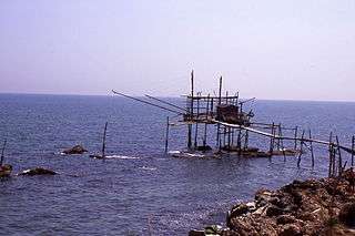
Trabucco of San Vito
The town is home to the "La Costa dei Trabocchi". Trabocchi are giant wooden platforms built since 1400, in the middle of the sea. They can be seen from the town of Ortona to Fossacesia. For local fisherman this was one of the method to fish abundant catch for the residents.
Notable residents
- Gabriele D'Annunzio, poet, lived in the town in 1900.
- Stanislao Gastaldon (1861–1939), the composer of "Musica Proibita", spent his early childhood in San Vito Chietino.[2]
Notes and references
- ↑ Data from Istat.
- ↑
- Sbrocchi, Vito (April 18, 2003). "Il compositore Gastaldon, celebre alla fine dell'Ottocento, trascorse l'infanzia a San Vito" Archived 2011-09-28 at the Wayback Machine.. Il Tempo (in Italian)
External links
| Wikimedia Commons has media related to San Vito Chietino. |

This article is issued from
Wikipedia.
The text is licensed under Creative Commons - Attribution - Sharealike.
Additional terms may apply for the media files.