Bucchianico
| Bucchianico | |
|---|---|
| Comune | |
| Comune di Bucchianico | |
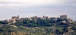 Panorama of Bucchianico | |
.svg.png) Bucchianico within the Province of Chieti | |
 Bucchianico Location of Bucchianico in Italy | |
| Coordinates: 42°18′N 14°10′E / 42.300°N 14.167°ECoordinates: 42°18′N 14°10′E / 42.300°N 14.167°E | |
| Country | Italy |
| Region | Abruzzo |
| Province | Chieti (CH) |
| Frazioni | Annunziata, Cervinelli, Colle Sant'Antonio, Feudo, Pozzo Nuovo, Pubblicone, Santa Maria Casoria, Piane |
| Government | |
| • Mayor | Gianluca De Leonardis |
| Area | |
| • Total | 38 km2 (15 sq mi) |
| Elevation | 360 m (1,180 ft) |
| Population (28 February 2017)[1] | |
| • Total | 5,195 |
| • Density | 140/km2 (350/sq mi) |
| Demonym(s) | Bucchianichesi |
| Time zone | UTC+1 (CET) |
| • Summer (DST) | UTC+2 (CEST) |
| Postal code | 66011 |
| Dialing code | 0871 |
| Patron saint | St. Camillus de Lellis |
| Saint day | 15 July |
| Website | Official website |
Bucchianico (locally Vicchièneche) is a comune and town in the province of Chieti in the Abruzzo region of Italy.
Geography
The town is situated on a hill between the valleys Alento river and Bucchianico Foro, and has a view extending from the Maiella to the Adriatic Sea. Its territory is hilly, with a significant presence of olive groves and vineyards. The climate is temperate, with winter temperatures about 6 °C (43 °F) and summer at about 23.5 °C (74 °F) and relatively abundant rains, which total around 1,000 millimetres (39 in) and are mainly concentrated in late autumn.
The municipality borders with Casacanditella, Casalincontrada, Chieti, Fara Filiorum Petri, Ripa Teatina, Roccamontepiano, Vacri and Villamagna.
References
External links
| Wikimedia Commons has media related to Bucchianico. |

This article is issued from
Wikipedia.
The text is licensed under Creative Commons - Attribution - Sharealike.
Additional terms may apply for the media files.