San Jose de Buan, Samar
| San Jose de Buan | |
|---|---|
| Municipality | |
| Municipality of San Jose de Buan | |
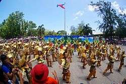 Kalinayan Festival during the Samar Day 2014 "Festival of Festivals". | |
| Nickname(s): Heart of Samar Island | |
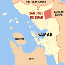 Map of Samar with San Jose de Buan highlighted | |
.svg.png) San Jose de Buan Location within the Philippines | |
| Coordinates: 12°03′N 125°04′E / 12.05°N 125.07°ECoordinates: 12°03′N 125°04′E / 12.05°N 125.07°E | |
| Country |
|
| Region | Eastern Visayas (Region VIII) |
| Province | Samar |
| District | 2nd district of Samar |
| Barangays | 14 (see Barangays) |
| Government [1] | |
| • Type | Sangguniang Bayan |
| • Mayor | Ananias S. Rebato |
| • Electorate | 4,730 voters (2016) |
| Area [2] | |
| • Total | 366.90 km2 (141.66 sq mi) |
| Population (2015 census)[3] | |
| • Total | 7,769 |
| • Density | 21/km2 (55/sq mi) |
| Time zone | UTC+8 (PST) |
| ZIP code | 6714 |
| PSGC | 086014000 |
| IDD : area code | +63 (0)55 |
| Climate type | Tropical rainforest climate |
| Income class | 4th municipal income class |
| Revenue (₱) | 77,951,386.79 (2016) |
| Native languages |
Waray Tagalog |
| Website |
elgu |
San Jose de Buan, officially the Municipality of San Jose de Buan, is a 4th class municipality in the province of Samar, Philippines. According to the 2015 census, it has a population of 7,769 people.[3]
San Jose de Buan was a municipal district of Gandara from 1948 to 1960, and was converted into a municipality in 1969.
Barangays
San Jose de Buan is politically subdivided into 14 barangays.
Demographics
| Population census of San Jose de Buan | ||
|---|---|---|
| Year | Pop. | ±% p.a. |
| 1918 | 382 | — |
| 1939 | 633 | +2.43% |
| 1948 | 646 | +0.23% |
| 1960 | 1,372 | +6.48% |
| 1970 | 2,530 | +6.30% |
| 1975 | 3,250 | +5.15% |
| 1980 | 5,455 | +10.91% |
| 1990 | 4,217 | −2.54% |
| 1995 | 5,471 | +5.00% |
| 2000 | 6,438 | +3.55% |
| 2007 | 6,814 | +0.79% |
| 2010 | 6,563 | −1.36% |
| 2015 | 7,769 | +3.26% |
| Source: Philippine Statistics Authority[3][4][5][6] | ||
References
- ↑ "Municipality". Quezon City, Philippines: Department of the Interior and Local Government. Retrieved 31 May 2013.
- ↑ "Province: Samar (Western Samar)". PSGC Interactive. Quezon City, Philippines: Philippine Statistics Authority. Retrieved 12 November 2016.
- 1 2 3 Census of Population (2015). "Region VIII (Eastern Visayas)". Total Population by Province, City, Municipality and Barangay. PSA. Retrieved 20 June 2016.
- ↑ Census of Population and Housing (2010). "Region VIII (Eastern Visayas)". Total Population by Province, City, Municipality and Barangay. NSO. Retrieved 29 June 2016.
- ↑ Censuses of Population (1903–2007). "Region VIII (Eastern Visayas)". Table 1. Population Enumerated in Various Censuses by Province/Highly Urbanized City: 1903 to 2007. NSO.
- ↑ "Province of Samar (Western Samar)". Municipality Population Data. Local Water Utilities Administration Research Division. Retrieved 17 December 2016.
External links
- Philippine Standard Geographic Code
- Philippine Census Information
- Local Governance Performance Management System
Places adjacent to San Jose de Buan, Samar | ||||||||||
|---|---|---|---|---|---|---|---|---|---|---|
| ||||||||||
This article is issued from
Wikipedia.
The text is licensed under Creative Commons - Attribution - Sharealike.
Additional terms may apply for the media files.