San Gavino Monreale
| San Gavino Monreale Santu ‘Engiu | ||
|---|---|---|
| Comune | ||
| Comune di San Gavino Monreale | ||
.jpg) | ||
| ||
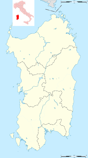 San Gavino Monreale Location of San Gavino Monreale in Sardinia | ||
| Coordinates: 39°33′N 8°48′E / 39.550°N 8.800°ECoordinates: 39°33′N 8°48′E / 39.550°N 8.800°E | ||
| Country | Italy | |
| Region | Sardinia | |
| Province | South Sardinia | |
| Government | ||
| • Mayor | Carlo Tomasi | |
| Area | ||
| • Total | 87.4 km2 (33.7 sq mi) | |
| Elevation | 51 m (167 ft) | |
| Population (31 December 2017)[1] | ||
| • Total | 8,594 | |
| • Density | 98/km2 (250/sq mi) | |
| Demonym(s) | Sangavinesi | |
| Time zone | UTC+1 (CET) | |
| • Summer (DST) | UTC+2 (CEST) | |
| Postal code | 09037 | |
| Dialing code | 070 | |
| Patron saint | St. Clare | |
| Saint day | August 12 | |
| Website | Official website | |
San Gavino Monreale (Sardinian: Santu ‘Engiu) is a comune (municipality) in the Province of South Sardinia in the Italian region Sardinia, located about 45 kilometres (28 mi) northwest of Cagliari, and roughly halfway between the latter and the town of Oristano.
San Gavino Monreale borders the following municipalities: Gonnosfanadiga, Pabillonis, Sanluri, Sardara, Villacidro. It is home to a castle.
History
The area of San Gavino was already settled in the Nuragic era, but the centre is of medieval origine. It was a possession of the Giudicato of Arborea and, later, of the Aragonese, being mostly destroyed in the ensuing war. Subsequently it was a fief of the Centelles and of the Osorio families, who held it until 1839.
People
- Fabio Aru, cyclist
- Raimondo Inconis, musician
References
| Wikimedia Commons has media related to San Gavino Monreale. |
External links
- San Gavino Monreale . Net Italian website dedicated to San Gavino Monreale
This article is issued from
Wikipedia.
The text is licensed under Creative Commons - Attribution - Sharealike.
Additional terms may apply for the media files.