Muravera
| Muravera Murera | ||
|---|---|---|
| Comune | ||
| Comune di Muravera | ||
|
| ||
| ||
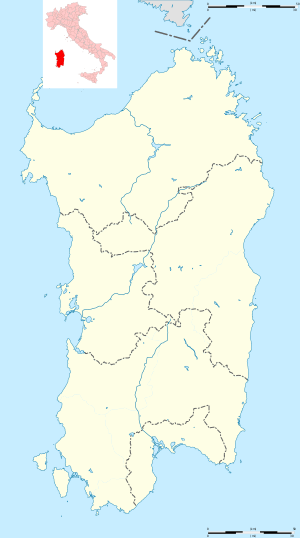 Muravera Location of Muravera in Sardinia | ||
| Coordinates: 39°25′N 9°34′E / 39.417°N 9.567°E | ||
| Country | Italy | |
| Region | Sardinia | |
| Province | South Sardinia | |
| Frazioni | Capo Ferrato, Costa Rei, Feraxi | |
| Government | ||
| • Mayor | Marco Sebastiano Falchi | |
| Area | ||
| • Total | 94.7 km2 (36.6 sq mi) | |
| Elevation | 9 m (30 ft) | |
| Population (1 January 2008)[1] | ||
| • Total | 5,155 | |
| • Density | 54/km2 (140/sq mi) | |
| Demonym(s) | Muraveresi | |
| Time zone | UTC+1 (CET) | |
| • Summer (DST) | UTC+2 (CEST) | |
| Postal code | 09043 | |
| Dialing code | 070 | |
| Website | Official website | |
Muravera (Sardinian: Murera, Latin: Sarcapos)[2] is a comune (municipality) in the Province of South Sardinia in the Italian region Sardinia, located about 45 kilometres (28 mi) northeast of Cagliari in the Sarrabus.
It is a centre of citrus production, as well as a tourist resort, including several fine beaches such as that of Costa Rei.
References
- ↑ All demographics and other statistics: Italian statistical institute Istat.
- ↑ Richard Talbert, Barrington Atlas of the Greek and Roman World, ( ISBN 0-691-03169-X), Map 48.
External links
| Wikimedia Commons has media related to Muravera. |

This article is issued from
Wikipedia.
The text is licensed under Creative Commons - Attribution - Sharealike.
Additional terms may apply for the media files.