San Antonio, Canelones
| San Antonio | |
|---|---|
| Village | |
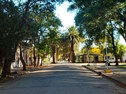 Marcelino-Moreira street, San Antonio, Canelones | |
 San Antonio Location in Uruguay | |
| Coordinates: 34°27′0″S 56°5′0″W / 34.45000°S 56.08333°WCoordinates: 34°27′0″S 56°5′0″W / 34.45000°S 56.08333°W | |
| Country |
|
| Department | Canelones Department |
| Population (2011) | |
| • Total | 1,489 |
| Time zone | UTC -3 |
| Postal code | 90002 |
| Dial plan | +598 4313 (+4 digits) |
San Antonio is a village in the Canelones Department of southern Uruguay.
San Antonio is also the name of the municipality to which the town belongs.
Location
The village is located on Km.55 of Route 33, 3.3 kilometres (2.1 mi) south of its intersection with Route 81.
History
Its status was elevated to "Pueblo" (village) by Decree of 14 November 1875.[1]
Population
In 2011 San Antonio had a population of 1,489.[2] The Intendencia de Canelones has estimated a population of 3,552 for the municipality.[3]
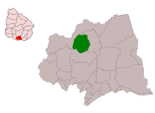
Location map of the Municipality of San Antonio
| Year | Population |
|---|---|
| 1908 | 2,919 |
| 1963 | 899 |
| 1975 | 1,120 |
| 1985 | 1,106 |
| 1996 | 1,293 |
| 2004 | 1,434 |
| 2011 | 1,489 |
Source: Instituto Nacional de Estadística de Uruguay[1]
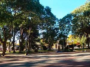
The central square of San Antonio, Canelones.
Places of worship
- St. Anthony of Padua Parish Church (Roman Catholic)
References
- 1 2 "Statistics of urban localities (1908–2004)" (PDF). INE. 2012. Retrieved 9 September 2012.
- ↑ "Censos 2011 Cuadros Canelones". INE. 2012. Retrieved 25 August 2012.
- ↑ "Municipio de San Antonio". Comuna Canaria / Dpto. de Canelones. Retrieved 27 August 2012.
External links
| Wikimedia Commons has media related to San Antonio, Canelones. |
Capital: Canelones | ||
| Towns and villages |
|  |
| Resorts of the Ciudad de la Costa | ||
| Sights |
| |
This article is issued from
Wikipedia.
The text is licensed under Creative Commons - Attribution - Sharealike.
Additional terms may apply for the media files.