Canelones, Uruguay
| Canelones | |
|---|---|
| Capital city & Municipality | |
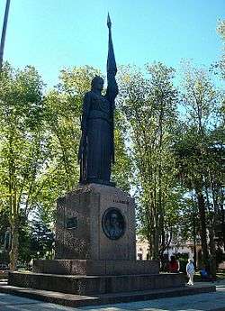 Monument "A La Bandera" in the central square | |
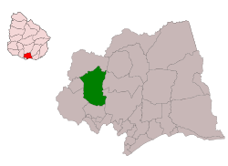
 Canelones Location within Uruguay | |
| Coordinates: 34°31′0″S 56°17′0″W / 34.51667°S 56.28333°WCoordinates: 34°31′0″S 56°17′0″W / 34.51667°S 56.28333°W | |
| Country |
|
| Department |
|
| Municipality | Canelones |
| Founded | 1782 |
| Founded by | Juan Miguel de Laguna |
| Elevation | 29 m (95 ft) |
| Population (2011 Census) | |
| • Total | 19,865 |
| • Demonym | canario (m) / canaria (f) |
| Time zone | UTC -3 |
| Postal code | 90000 |
| Dial plan | +598 433 (+5 digits) |
| Climate | Cfa |
Canelones (Spanish pronunciation: [kaneˈlones]) is the capital of the department of Canelones in Uruguay. Its name is derived from a species of cinnamon, which is called "canelón", growing along the banks of the homonymous river.[1] Since 2010, the city is also the seat of the municipality of Canelones.
Location
The city is located on Route 5 about 50 kilometres (31 mi) North of Montevideo and on its intersection with Route 64. It lies on the west bank of the river Arroyo Canelón Chico.
History
It was founded on 24 April 1783 under the name "Villa Guadalupe". It became capital of one of the nine earlier Departments of the Republic. The railroad arrived here in 1874, while in 1908 National Route 5 from Montevideo was inaugurated. On 23 March 1916, it was renamed to "Canelones" and its status was elevated to "Ciudad" (city) by the Act of Ley Nº 5.400.[2]
Population
According to the 2011 census, Canelones had a population of 19,865.[3] In 2010, the Intendencia de Canelones had recorded a population of 25,961 for the municipality during the elections.[1] While Canelones is the capital of the department of the same name, it has a considerably smaller population compared with two other cities in the department, Ciudad de la Costa and Las Piedras.
| Year | Population |
|---|---|
| 1908 | 8,523 |
| 1963 | 14,028 |
| 1975 | 15,988 |
| 1985 | 17,323 |
| 1996 | 19,388 |
| 2004 | 19,631 |
| 2011 | 19,865 |
| 2017 | 32,743 |
Source: Instituto Nacional de Estadística de Uruguay[2]
Economic activity
The city and the department have numerous small to large vineyards and wineries. In 1987 the cold-storage facility "Frigorífico Canelones" was founded, which ever since became the principal industry of the city.[1]
Government and infrastructure
The civil aviation agency of the country, National Civil Aviation and Aviation Infrastructure Direction (DINACIA), has its headquarters in Canelones.[4]
Places of worship
Noted local people
- Diego Lugano, captain of the Uruguay national football team
- Pablo Gabriel García, football player for PAOK F.C.
- Matías Vecino, footballer
- Facundo Peraza (born July 27, 1992), footballer
- Robert Siboldi, Former football player and former manager[5] of Santos Laguna
- Sebastián Rodríguez (born 1992), footballer
See also
References
- 1 2 3 "ELECCIONES - Canelones". El Observador. Archived from the original on 12 March 2012. Retrieved 2 February 2012.
- 1 2 "Statistics of urban localities (1908–2004)" (PDF). INE. 2012. Retrieved 6 September 2012.
- ↑ "Censos 2011 Cuadros Canelones". INE. 2012. Archived from the original on 10 October 2012. Retrieved 25 August 2012.
- ↑ "Inicio." (Archive) National Civil Aviation and Aviation Infrastructure Direction. Retrieved on April 17, 2012. "Avda. Camino de las Industrias Wilson Ferreira Aldunate (ex Camino Carrasco) 5519, Canelones, Uruguay."
- ↑ ESPN. "Santos' Siboldi resigns after staff-player dustup". ESPN.com.
External links
Capital: Canelones | ||
| Towns and villages |
|  |
| Resorts of the Ciudad de la Costa | ||
| Sights |
| |