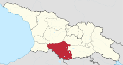
Samtskhe–Javakheti
| Samtskhe–Javakheti სამცხე-ჯავახეთი | |
|---|---|
| Mkhare (region) | |
 | |
| Country |
|
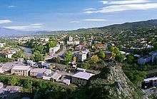
| Seat | Akhaltsikhe |
| Subdivisions |
1 self-governing city 6 municipalities |
| Government | |
| • Governor | Lasha Chkadua |
| Area | |
| • Total | 6,413 km2 (2,476 sq mi) |
| Population (2014 census) | |
| • Total | 160,262 |
| • Density | 25/km2 (65/sq mi) |
| ISO 3166 code | GE-SJ |
Samtskhe–Javakheti (Georgian: სამცხე-ჯავახეთი, pronounced [sɑmtsʰxɛ dʒɑvaxɛtʰi]), is a region (Mkhare) formed in 1995 in southern Georgia from the historical provinces of Meskheti (Samtskhe), Javakheti and Tori (Borjomi gorge). Akhaltsikhe is its capital.
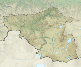
The region comprises six administrative districts: Akhaltsikhe, Adigeni, Aspindza, Borjomi, Akhalkalaki and Ninotsminda. There are 5 town, 6 townlets, 67 community and village sakrebulos (assemblies), and 268 villages in the region. Samtskhe–Javakheti is bordered by the regions of Adjara to the west, Guria and Imereti to the north, Shida Kartli and Kvemo Kartli to the north-east and to the east, and by Armenia and Turkey to the south and southwest.
The Baku-Tbilisi-Ceyhan oil pipeline, the South Caucasus natural gas pipeline, and the Kars–Tbilisi–Baku railway pass through the region.
General Informations
The area of the region is 6413 km squares and the population is of 160262 inhabitants. The administrative center of the region is Akhaltsikhe. There are 353 populated areas, including :
- 5 cities : Akhaltsikhe, Akhalkalaki, Borjomi, Vale and Ninotsminda
- 7 "daba" : Bakuriani, Bakurianis Andeziti, Tsagveri, Akhaldaba, Adigeni, Abastumani, Aspindza
- 258 villages
History
The current division of Georgia into "regions" (Mkhare) was introduced by the Shevardnadze government in the mid-1990s, partly as a response to the secession of Abkhazia and the South Ossetia conflict. Samtskhe–Javakheti was basically formed by combining the two traditional provinces of Meskheti (Samtskhe) and Javakheti.
Meskheti
The ancient tribes of Meskhi (or Moschi) and Mosiniks are the first known inhabitants of the area. Some scholars credit the Mosiniks (or Mossynoeci) with the invention of iron metallurgy. From the 2nd millennium to the 4th century BC, Meskheti was believed to be part of the Kingdom of Diauehi, in the 4th century BC to the 6th century AD part of the Kingdom of Iberia. From the 10th to the 15th century it was part of the united Georgian Kingdom. In the 16th century Meskheti was integrated into the Safavid Empire, followed by the Ottoman Empire. After the conclusion of the Russo-Persian War of 1826-28, it was a part of Russian Tiflis Governorate from 1817 till 1829, from 1918 to 1921 part of the Democratic Republic of Georgia, and from 1921 to 1990 part of the Georgian SSR. After independence from the USSR Meskheti was reinstalled as a province of Georgia, and later cast into the new Samtskhe–Javakheti region.
Javakheti
In ancient sources, the region was recorded as Zabakha in 785 BC, by the king Argishti I of Urartu. According to Cyril Toumanoff, Javakheti was part of the Iberian duchy of Tsunda from the 4th or 3rd century BC. Saint Nino entered Iberia from Javakheti, and, following the course of the River Kura, she arrived in Mtskheta, the capital of the kingdom, once there, she eventually began to preach Christianity, which culminated by Christianization of Iberia.
In struggle against the Arab occupation, Bagrationi dynasty came to rule over Tao-Klarjeti and established the Kouropalatate of Iberia. rulers of Tao-Klarjeti fought the Arabs from there, gradually incorporating the surrounding lands of Samtskhe and Javakheti, along with a few other lesser lands, from the Arab dominance. For a long time the region became a cultural safe-house and one of the most important religious centers of Georgia.
In the mid-10th century, Javakheti was incorporated into Kingdom of Abkhazia. In 964 Leon III of Abkhazia extended his influence to Javakheti, during his reign was built Kumurdo Cathedral.[1][2] In subsequent centuries, Javakheti was staying in hands of unified Georgian monarchy and had a period of significant development: lot of bridges, churches, monasteries, and royal residences (Lgivi, Ghrtila, Bozhano, Vardzia) were built. From the 11th century, the center of upper Javakheti became Akhalkalaki. From the 10th century, the center of lowland Javakheti was Tmogvi. From the 12th century, the domain was ruled by representatives of the feudal family of Toreli.
In the 15th century, Javakheti was part of the principality of Samtskhe-Saatabago. In the 16th century, the region, as well as the adjacent territories of western Georgia, was occupied by the Ottoman Empire. The Georgian population of Javakheti was displaced to inner regions of Georgia such as Imereti and Kartli. Those who remained gradually became Muslim.
As a result of the struggles of the Russian Empire with the Ottomans, Russian authorities settled Christian Armenians and Greeks in the area after 1828.[3] Armenian refugees from the Armenian Genocide in the Ottoman Empire came in the early 20th century. Also a large number of Russian Doukhobor sect members settled the region.
Soviet era
Georgia came fully under Soviet control in 1921, after the Red Army invasion of Georgia. The remaining Muslim minority in Meskheti, also known as "Meskhetian Turks", were deported in cattle-trucks to Central Asia by order of Stalin and settled within an area that overlaps the boundaries of the modern nations of Kazakhstan, Kyrgyzstan, and Uzbekistan. Today, many are still dispersed across those countries. Of the 100,000 forcibly deported, a total of 10,000 perished.[4]
Demographics
.svg.png)
The Georgian census of 2014 officially recorded 160,504 inhabitants in the region, of whom 81,089 (50.5%) were Armenians, 77,498 (48.3%) were Georgians, 712 (0.4%) were Russians and 1,194 (0.8%) belonged to other ethnic groups.[5] The most densely populated districts are the Akhaltsikhe and Akhalkalaki municipalities.
According to the 2014 census, 93% of the inhabitants of Akhalkalaki Municipality and 95% of Ninotsminda Municipality are Armenians.
Tourist attractions
The major tourist attractions are the cave monasteries of Vardzia (which was founded by Queen Tamar in 1185), Vanis Kvabebi (which dates from the 8th century), Rabati Castle and Khertvisi fortress. Also, among national visitors is very popular 10th century Sapara Monastery, Tmogvi fortress, and 8th century Zarzma monastery.
See also
References
- ↑ "Kumurdo Church". Georgian patriarchate, Eparchy of Shemoqmedi. Archived from the original on 21 July 2011. Retrieved 5 March 2011.
- ↑ "Kumurdo". Parliament of Georgia. Retrieved 5 March 2011.
- ↑ Boeschoten, Hendrik; Rentzsch, Julian (2010). Turcology in Mainz. p. 142. ISBN 978-3-447-06113-1. Retrieved 9 July 2011.
- ↑ https://www.theguardian.com/news/2003/apr/05/guardianobituaries.usa as retrieved on 29 Apr 2008 20:59:44 GMT
- ↑ "Total population by regions and ethnicity". National Statistics Office of Georgia. Retrieved 5 Aug 2017.
External links
- Friends at Dinner, Foes at Politics (about socio-economic problems of the region)
- Obstacles Impeding the Regional Integration of the Javalkheti Region, an ECMI working paper (PDF format)
| Autonomous Republics | .svg.png) | |
|---|---|---|
| Regions | ||
| City with special status |
| |
| Other | ||