Akhaltsikhe
| Akhaltsikhe ახალციხე | |
|---|---|
 | |
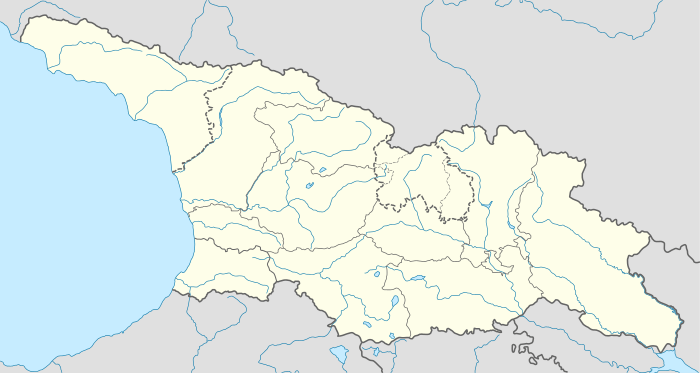 Akhaltsikhe Location of Akhaltsikhe in Georgia  Akhaltsikhe Akhaltsikhe (Samtskhe-Javakheti) | |
| Coordinates: 41°38′20″N 42°59′10″E / 41.63889°N 42.98611°E | |
| Country |
|
| mkhare | Samtskhe-Javakheti |
| Elevation | 992 m (3,255 ft) |
| Population (2014)[1] | |
| • Total | 17,903 |
| Time zone | UTC+4 (Georgian Time) |
| • Summer (DST) | UTC+5 |
Akhaltsikhe (Georgian: ახალციხე [ɑxɑltsʰixɛ], literally "new castle"; formerly known as Lomsia) is a small city in Georgia's southwestern region (mkhare) of Samtskhe–Javakheti. It is situated on the both banks of a small river Potskhovi, which separates the city to the old city in the north and new in the south.
In the old part of the city one can see the great Rabati Castle, built by the Ottomans around a mosque, and St. Marine's Church. The hills nearby the city harbour the Sapara Monastery (10th–14th centuries).
History
.jpg)
The city is first mentioned in the chronicles in the 12th century. In the 12th–13th centuries it was the seat of the House of Akhaltsikhe, dukes of Samtskhe, whose two most illustrious representatives were Shalva and Ivane Akhaltsikheli. From the 13th up to the 17th century the city and Samtkhe were governed by the House of Jaqeli.
In 1576 the Ottomans took it and from 1628 the city became the centre of the Akhalzik Eyalet of the Ottoman Empire as "Ahıska".
In 1828, during the Russo-Turkish War of 1828–1829, Russian troops under the command of General Paskevich captured the city and, as a consequence of the 1829 Treaty of Adrianople (Edirne), it was ceded to the Russian Empire as part of first Kutais and then Tiflis Governorates.
In the late 1980s the city was host to the Soviet Army's 10th Guards Motor Rifle Division, which became a brigade of the Georgian land forces after the fall of the Soviet Union.
Population
| Year | Georgians | Armenians | Russians | Jews | Others | Total | |||||
|---|---|---|---|---|---|---|---|---|---|---|---|
| 1886 | 2,733 | 17% | 10,417 | 64.6% | 146 | 0.9% | 2,545 | 15.8% | 275 | 1.7% | 16,116 |
| 1897[3][4] | 3,578 | 23.3% | 9,035 | 58.8% | 1,172 | 7.3% | 438 | 2.9% | 1,134 | 3.4% | 15,357 |
| 1926[5] | 1,817 | 14.8% | 6,516 | 52.9% | 1.425 | 11.6% | 94 | 0.8% | % | 12,310 | |
| 1959[6] | 6,801 | 25.7% | 14.341 | 54.1% | 3,509 | 13.2% | 368 | 1.4% | % | 26,497 | |
| 1989 | 24,570 | ||||||||||
| 2014[7] | 12,838 | 71.7% | 4,781 | 26.7% | 75 | 0.4% | 208 | 1.1% | 17,903 | ||
Climate
| Climate data for Akhaltsikhe | |||||||||||||
|---|---|---|---|---|---|---|---|---|---|---|---|---|---|
| Month | Jan | Feb | Mar | Apr | May | Jun | Jul | Aug | Sep | Oct | Nov | Dec | Year |
| Average high °C (°F) | 0.2 (32.4) |
2.3 (36.1) |
7.5 (45.5) |
14.1 (57.4) |
19.0 (66.2) |
22.1 (71.8) |
24.9 (76.8) |
25.1 (77.2) |
21.5 (70.7) |
15.7 (60.3) |
8.6 (47.5) |
3.0 (37.4) |
13.7 (56.6) |
| Daily mean °C (°F) | −4.2 (24.4) |
−2.3 (27.9) |
2.3 (36.1) |
7.9 (46.2) |
12.7 (54.9) |
15.7 (60.3) |
18.6 (65.5) |
18.7 (65.7) |
14.7 (58.5) |
9.5 (49.1) |
3.7 (38.7) |
−1.3 (29.7) |
8 (46.4) |
| Average low °C (°F) | −8.6 (16.5) |
−6.9 (19.6) |
−2.9 (26.8) |
1.7 (35.1) |
6.4 (43.5) |
9.4 (48.9) |
12.4 (54.3) |
12.4 (54.3) |
8.0 (46.4) |
3.4 (38.1) |
−1.1 (30) |
−5.5 (22.1) |
2.4 (36.3) |
| Average precipitation mm (inches) | 44 (1.73) |
40 (1.57) |
38 (1.5) |
60 (2.36) |
78 (3.07) |
91 (3.58) |
56 (2.2) |
52 (2.05) |
52 (2.05) |
59 (2.32) |
54 (2.13) |
56 (2.2) |
680 (26.76) |
| Source: Climate-Data.org | |||||||||||||
International relations
Twin towns and sister cities
Akhaltsikhe is twinned with:
People associated with Akhaltsikhe

- Gregorio Pietro Agagianian (1895–1971), Armenian Catholic Cardinal, papabile
- David Baazov, rabbi in Akhaltsikhe (1918)
- Aghan Ephrikian (?-1840), Pasha and governor
- Aram Ghanalanyan (1909–1983), Armenian philologist, folklorist, member of Armenian National Academy of Sciences
- Hovhannes Kajaznuni (1868–1938), first prime minister of the First Republic of Armenia
- Ahmed-Pasha Khimshiashvili (?-1836), Pasha of Ahiska
- Sergo Kobuladze (1909–1978), painter and illustrator
- Hakob Kojoyan (1883–1959), Soviet Armenian artist
- Shalva Maglakelidze, plenipotentiary for the Russian Provisional Government and then for the government of Georgia in Akhaltsikhe (1917–1918)
- Stepan Malkhasyants, Armenian academician
- Palavandishvili family
- Giorgi Mazniashvili, governor general of Akhaltsikhe (1919–1920)
- Natela Svanidze, Georgian composer
- Michel Tamarati (1858–1911), Georgian Catholic priest and historian
- Vakhtang Tchutchunashvili (?-1668), usurper of Imereti throne, fled to Ahiska after being deposed
- Vakhtang V, King of Kartli, fled to Ahiska after a coup failure
- Lusine Zakaryan (1937–1991), Soviet Armenian soprano singer
Archaeology
The highland environment between Akhaltsikhe and Aspindza presents a varied and complex array of archaeological features in different locations, elevations and topographies. This includes the alluvial flood-plain of the Kura River, and all the way to the high grasslands.
Human occupation is attested already in the Early Bronze Age (4th millennium BC) and later.
The Roman and medieval periods artifacts are also strongly represented in the area.
Amiranis Gora
On the northeastern outskirts of Akhaltsikhe is an important archaeological site of Amiranis Gora.[9] It was excavated by Chubinishvili.[10] The earliest carbon date for Amiranis Gora is 3790-3373 cal BC. It was obtained from the charcoal of the metallurgical workshop which belonged to the earliest building horizon of Amiranis Gora[11] This indicates a division of the metallurgical production in the extractive and processing branches.[12]
Amiranis Gora is an important reference point for the study of the Early Bronze Age Kura-Araxes culture, also known as the Early Transcaucasian Culture. The many references include the architecture, burial practices, material culture and metallurgy.[13]
Amiranis Gora is one of the best sites with fixed stratigraphy of the Kura-Araxes culture. The carbon date for the Kura-Araxes material at Amiranis Gora is 3630-3048 cal B.C., which is very early.[14]
See also
References
- ↑ "Population Census 2014". www.geostat.ge. National Statistics Office of Georgia. November 2014. Retrieved 2 June 2016.
- ↑ "население грузии". Retrieved October 8, 2016.
- ↑ "Демоскоп Weekly - Приложение. Справочник статистических показателей". Archived from the original on August 18, 2016. Retrieved October 8, 2016.
- ↑ "АХАЛЦИХСКИЙ УЕЗД (1897 г.)". Retrieved October 8, 2016.
- ↑ http://www.ethno-kavkaz.narod.ru/axalcixe26.html
- ↑ http://www.ethno-kavkaz.narod.ru/axalcixe59.html
- ↑
- ↑ "Climate: Akhaltsikhe". Retrieved 2016-02-27.
- ↑ Archaeological Investigations at Chobareti in Southern Georgia, the Caucasus Author(s): KAKHIANI, Kakha , SAGONA, Antonio, SAGONA, Claudia, KVAVADZE, Eliso , BEDIANASHVILI, Giorgi , MASSAGER, Erwan , MARTIN, Lucie , HERRSCHER, Estelle , MARTKOPLISHVILI, Inga , BIRKETT-REES, Jessie , LONGFORD, Catherine Journal: Ancient Near Eastern Studies Volume: 50 Date: 2013 Pages: 1-138 doi:10.2143/ANES.50.0.2975510
- ↑ Chubinishvili, T., 1963: Amiranis Gora, Tbilisi: Sabchota Saqartvelo
- ↑ Kushnareva & Chubinishvili 1970: 114, Fig. 5.1
- ↑ THE BEGINNINGS OF METALLURGY Proceedings of the International Conference, Bochum 1995
- ↑ Palumbi 2008; Kiguradze and Sagona 2003; Burney and Lang 1971
- ↑ THE BEGINNINGS OF METALLURGY Proceedings of the International Conference, Bochum 1995
| Wikivoyage has a travel guide for Akhaltsikhe. |
| Wikisource has the text of the 1911 Encyclopædia Britannica article Akhaltsikhe. |
| Wikimedia Commons has media related to Akhaltsikhe. |
| Authority control |
|---|
Samtskhe–Javakheti History Museum Coordinates: 41°38′20″N 42°59′10″E / 41.63889°N 42.98611°E
| Autonomous Republic of Abkhazia |   | |
|---|---|---|
| Autonomous Republic of Adjara | ||
| Guria |
| |
| Imereti | ||
| Kakheti | ||
| Mtskheta-Mtianeti | ||
| Samegrelo-Zemo Svaneti | ||
| Samtskhe-Javakheti |
| |
| Racha-Lechkhumi and Kvemo Svaneti |
| |
| Kvemo Kartli | ||
| Shida Kartli | ||
| Cities with local government | ||
| Capital city | ||