Salt Creek Covered Bridge
|
Salt Creek Covered Bridge | |
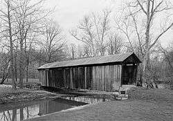 Photograph by Jet Lowe | |
 | |
| Nearest city | Norwich, Ohio |
|---|---|
| Coordinates | 39°59′55″N 81°50′24″W / 39.99861°N 81.84000°WCoordinates: 39°59′55″N 81°50′24″W / 39.99861°N 81.84000°W |
| Area | less than one acre |
| Built | 1876 |
| Built by | Fisher,Thomas; Romine,Jesse |
| Architectural style | Warren truss |
| NRHP reference # | 74001587[1] |
| Added to NRHP | September 10, 1974 |
The Salt Creek Covered Bridge, near Norwich in Perry Township, Muskingum County, Ohio, was built in 1876. It was listed on the National Register of Historic Places in 1974.[1]
It is located 3 miles (4.8 km) northwest of Norwich.
It spans Salt Creek about 10 miles (16 km) east of Zanesville, Ohio and is a Warren truss bridge.[2]
References
- 1 2 National Park Service (2013-11-02). "National Register Information System". National Register of Historic Places. National Park Service.
- ↑ Lorrie K. Owen, ed. (1999). "Ohio Historic Places Dictionary, Volume 2". Somerset Publishers, Inc. p. 1111. Retrieved September 8, 2018.
External links

| Topics | |
|---|---|
| Lists by states |
|
| Lists by insular areas | |
| Lists by associated states | |
| Other areas | |
| |
This article is issued from
Wikipedia.
The text is licensed under Creative Commons - Attribution - Sharealike.
Additional terms may apply for the media files.