Saline Island (Kentucky)
|
Saline Island | |
 | |
  | |
| Nearest city | Saline Mines, Kentucky |
|---|---|
| Coordinates | 37°34′49″N 88°08′02″W / 37.58028°N 88.13389°WCoordinates: 37°34′49″N 88°08′02″W / 37.58028°N 88.13389°W |
| Area | 200 acres (81 ha) |
| Built | 1864 |
| MPS | Caught in the Middle: The Civil War on the Lower Ohio River MPS |
| NRHP reference # | 98001291[1] |
| Added to NRHP | October 30, 1998 |
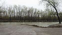
Saline Island, also known as Johnson Island, in the Ohio River near Saline Landing, Illinois, has historical significance dating to 1864 during the American Civil War. It was listed on the National Register of Historic Places in 1998.[1]
It is located at the confluence of the Saline River with the Ohio River, at miles 865-67 of the latter, on the Illinois side of the river, but the island is part of Kentucky.[2]
References
- 1 2 National Park Service (2010-07-09). "National Register Information System". National Register of Historic Places. National Park Service.
- ↑ James E. Jacobsen (March 20, 1998). "National Register of Historic Places Registration: Saline Island / Johnson Island / UN-32". National Park Service. Retrieved April 8, 2018. With two photos from 1997.
| Topics | |
|---|---|
| Lists by states |
|
| Lists by insular areas | |
| Lists by associated states | |
| Other areas | |
| |
This article is issued from
Wikipedia.
The text is licensed under Creative Commons - Attribution - Sharealike.
Additional terms may apply for the media files.