Sakishima Beacons
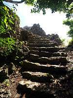
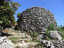
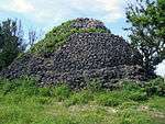
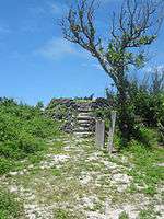
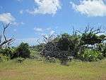
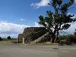
The Sakishima Beacons (先島諸島火番盛 Sakishima-shotō hibanmui) are a network of eighteen observation platforms and beacons dating to the early Edo period and located in the Sakishima Islands, Okinawa Prefecture, Japan. Erected in 1644 by the government of the Ryūkyū Kingdom at the instigation of the Satsuma overlords, at a time of international tension during the transition between the Ming and the Qing Dynasties of China, the beacons were responsible for monitoring and reporting on maritime traffic, with a view to restricting foreign vessels in accordance with the Tokugawa policy of sakoku, i.e. national seclusion.[1][2][3] After an initial survey by the Council for the Protection of Cultural Properties in 1993, due to uncertainties over land rights and difficulties of coordination between the involved municipalities, it was not until 2007 that they were jointly designated an Historic Site.[2][3][4]
Locations
There are eight beacons in the Miyako Islands and ten in the Yaeyama Islands.[2] Of those in the Miyako Islands, five are within the city of Miyakojima (on the islands of Miyakojima, Ikema, and Kurima), and three in the village of Tarama (on the islands of Tarama and Minna). Of those in the Yaeyama Islands, two are within the city of Ishigaki (on the island of Ishigaki), seven in the town of Taketomi (on the islands of Taketomi, Kuroshima, Upper and Lower Aragusuku, Hateruma, Kohamajima, and Hatoma), and one in the town of Yonaguni (on the island of Yonaguni).[5][6][7][8]
Operations
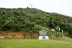
Records suggest that the beacon near Cape Hirakubo on Ishigaki was at one point manned by a team of four, who also slept on the site.[7] A different signal may have been given depending upon the origin of the ships.[7] A restaged beacon relay in November 2007 saw an attempt to pass signals along two routes: (1) Hateruma-Aragukusu (Shimoji)-Aragusuku (Kamiji)-Kuroshima-Taketomi-Ishigaki; and (2) Hatoma-Kohamajima-Taketomi-Ishigaki.[9] Along both routes the initial signal could not be seen from the next observation platform, due to rain; after restarting from the second station, both signals were successfully relayed to Ishigaki; in some instances it took up to ten minutes from the signal being observed for a fire to be lit sufficient for the smoke to be seen at the next station; the exercise highlighted the difficulty in transmitting signals by such a method in times of inclement weather and poor visibility.[9][10]
List of beacons

See also
| Wikimedia Commons has media related to Sakishima Beacons. |
References
- ↑ "先島諸島火番盛" [Sakishima Beacons] (in Japanese). Agency for Cultural Affairs. Retrieved 11 June 2012.
- 1 2 3 "先島諸島火番盛 国指定史跡に" [Sakishima Beacons - Designated a National Historic Site]. Ryūkyū Shimpō (in Japanese). 11 April 2007. Archived from the original on 7 March 2014. Retrieved 9 June 2012.
- 1 2 "「火番盛」国の史跡に3市町で10カ所指定" ["Beacons": Designation of A National Historic Site (with 10 component sites and spanning 3 municipalities)]. Yaeyama Mainichi Shimbun (in Japanese). 11 April 2007. Retrieved 9 June 2012.
- ↑ "先島諸島火番盛" [Sakishima Beacons] (in Japanese). Agency for Cultural Affairs. Retrieved 9 June 2012.
- 1 2 3 4 5 "宮古島の文化財 国関係" [Cultural Properties of Miyakojima (National)] (in Japanese). Miyakojima City. Archived from the original on 19 January 2012. Retrieved 9 June 2012.
- ↑ "史跡・文化財" [Historic Sites - Cultural Properties] (in Japanese). Tarama Village. Retrieved 11 June 2012.
- 1 2 3 "火番盛" [Beacons] (in Japanese). Ishigaki City. Archived from the original on 15 September 2010. Retrieved 9 June 2012.
- 1 2 3 "竹富町の文化財" [Cultural Properties of Taketomi] (in Japanese). Taketomi Town. Retrieved 9 June 2012.
- 1 2 "竹富町内7島で「のろし」リレー 350年以上前の情報伝達を再現" [Beacon Relay across Seven Islands of Taketomi Town: reproducing the signalling method of 350 years ago]. Yaeyama Mainichi Shimbun (in Japanese). 9 November 2011. Retrieved 9 June 2012.
- ↑ "琉球王府時代の「のろし」を再現-竹富町の7島と石垣で検証リレー" [Reproducing the beacons of the Ryukyu royal government across 7 islands of Taketomi and Ishigaki] (in Japanese). Ishigaki Keizai Shimbun. 9 November 2007. Retrieved 11 June 2012.
- ↑ "3.3 北部地域" [The Northern Region (p. 75)] (PDF) (in Japanese). Ishigaki City. Retrieved 9 June 2012.
- ↑ "3.4 西部地域" [The Western Region (p. 82)] (PDF) (in Japanese). Ishigaki City. Retrieved 9 June 2012.
- ↑ "小浜島" [Kohamajima] (in Japanese). Taketomi Town. Retrieved 9 June 2012.