Yonaguni, Okinawa
| Yonaguni 与那国町 Dunan | |||
|---|---|---|---|
| Town | |||
     Yonaguni Montage | |||
| |||
 Yonaguni Location in Japan | |||
| Coordinates: 24°28′5″N 123°0′17″E / 24.46806°N 123.00472°ECoordinates: 24°28′5″N 123°0′17″E / 24.46806°N 123.00472°E | |||
| Country | Japan | ||
| Region | Kyushu (Okinawa) | ||
| Prefecture | Okinawa Prefecture | ||
| District | Yaeyama | ||
| Government | |||
| • Mayor | Shukichi Hokama | ||
| Area | |||
| • Total | 28.95 km2 (11.18 sq mi) | ||
| Population (October 1, 2016) | |||
| • Total | 2,048 | ||
| • Density | 58.2/km2 (151/sq mi) | ||
| Symbols | |||
| • Tree | Chinese fan palm (Livistona chinensis) | ||
| • Flower | Lily (Lilium) | ||
| • Bird | Japanese white-eye (Zosterops japonicus) | ||
| • Flowering tree | Crape myrtle (Lagerstroemia) | ||
| • Butterfly | Atlas moth (Attacus atlas) | ||
| Time zone | UTC+9 (JST) | ||
| City hall address |
129 Aza-Yonaguni, Yonaguni-chō, Yaeyama-gun, Okinawa-ken 907-1801 | ||
| Website |
www | ||


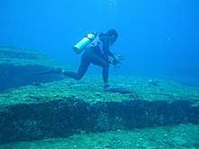
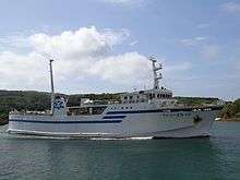
Yonaguni (与那国町 Yonaguni-chō, Yonaguni: Dunan, Yaeyama: Yunōn, Okinawan: Yunaguni) is a town located entirely on Yonaguni Island in Yaeyama District, Okinawa Prefecture, Japan. It is the westernmost municipality in Japan, and is known for billfish fishing and as a diving spot. In 1987, divers discovered the Yonaguni Monument, a rock formation that some believe may be man-made.
It is also home to two Ryūkyūan writing systems, pictographic "kaida-di" (also used on Ishigaki and Taketomi islands where it is called "kaida-ji") and the symbols used to indicate family names, "dāhan" (also used on Ishigaki Island where they are called "yāban").
History
Presently, the oldest confirmed ruins are the Tuguru Beach ruins. Due to the southern style stone tools found, it is thought that a culture influenced by Southeast Asia existed here at one time.
After this point, the history of the island of Yonaguni is unclear, but in the Gusuku Era, settlements were formed on the top of the plateau. The Shima Nakamura Ruins are one example, and it is known for being the birth village of the famous woman chief, San’ai Isoba.
From the time of the Ryūkyū Kingdom, Yonaguni prospered as a commerce center with Taiwan. Due to World War II, until it was placed under control of the United States Civil Administration of the Ryukyu Islands, the number of people involved in smuggling surged in the area. The population in 1947 had reached 12,000, but although Yonaguni became incorporated as a town, a crackdown on smuggling led to a sharp decrease in the population.[1]
Ishigaki and the surrounding towns and cities are discussing a merger, with the exception of Yonaguni which abstained, cutting the members of parliament from 12 in half, down to 6.
- 1522 Invaded by the Ryūkyū army and became a territory of the Ryūkyū Kingdom.
- 1872 The Ryūkyū Kingdom is abolished; in its place, the Ryūkyū Domain is established and the island becomes a territory of the Ryūkyū Domain.
- 1879 The Ryūkyū Domain is abolished and becomes Okinawa-ken.
- 1908 The island municipal system abolishes the magiri system, and the Ishigaki-magiri, Ōhama-magiri, and Miyara-magiri join the island of Yonaguni to become Yaeyama-son.
- 1914 Through a division of Yaeyama-son, the village of Yonaguni-son is formed.
- 1948 Yonaguni-chō is incorporated as a town.
Geography
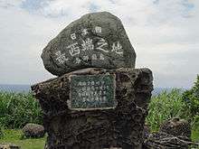
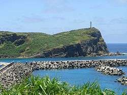
- Yonaguni is the westernmost part of Japan and is a midpoint between the island of Ishigaki and Taiwan. At Cape Irizaki (Yonagunian language: Irinzati) on the western edge of the island, there is a monument inscribed with the words: “The westernmost point in Japan.”
- The western third of the island is not part of Japan’s air defense identification zone or flight information region; instead, it sits in Taiwan’s air defense identification zone and flight information region. (Please refer to the article on Yonaguni Airport for more details.)
- The distance between Yonaguni and Hualien City, Taiwan is 111 km (69 mi) and therefore closer than Ishigaki, which is 118 km (73 mi) away. For further comparison, Yonaguni is much closer to Taipei (the capital of Taiwan) at approximately 160 km (99 mi) than its own capital (Tokyo), which is about 2,000 km (1,200 mi) away. Due to this it is attempting to establish closer relations with Taiwan, including attempting to set up easier access to and from cities in Taiwan, with irregular service to Hualien already established. Further cooperation has been opposed by the central government, thus the lack of further progress.
Rivers
- Tahara River (Okinawa)
Population
| Historical population | ||
|---|---|---|
| Year | Pop. | ±% |
| 1980 | 2,119 | — |
| 1985 | 2,054 | −3.1% |
| 1990 | 1,833 | −10.8% |
| 1995 | 1,801 | −1.7% |
| 2000 | 1,852 | +2.8% |
| 2005 | 1,796 | −3.0% |
| 2005 Census, Ministry of Internal Affairs and Communications - Statistics Department | ||
 | ||||||||||||||||||||||||||||
| Comparison of Population Distribution between Yonaguni and Japanese National Average | Population Distribution by Age and Sex in Yonaguni | |||||||||||||||||||||||||||
■Yonaguni ■Japan (average) |
■Male ■Female | |||||||||||||||||||||||||||
| ||||||||||||||||||||||||||||
| 2015 Census, Ministry of Internal Affairs and Communications - Statistics Department | ||||||||||||||||||||||||||||
Administration
- Mayor Shukichi Hokama
Transportation
Airport
- Japan Transocean Air (JTA) – JAL group
- Ishigaki Airport 30 min., one round trip flight daily (Boeing 737-400)
- Ryūkyū Air Commuter (RAC) – JAL and JTA groups
- Naha Airport 80 min., four round trip flights per week (Bombardier Dash 8 DHC-8-100)
- Ishigaki Airport 30 min., four round trip flights per week (Bombardier Dash 8 DHC-8-100)
Harbors
Kubura Harbor
- Fukuyama Maritime “Ferry Yonakuni”
- Ishigaki Harbor 4 hr. 30 min. (only two round trips per week)
- Naha Harbor (irregular schedule)
Sonai Harbor
Roads
- Okinawa Prefectural Road 216 – Yonaguni Island Route
- Okinawa Prefectural Road 217 – Yonaguni Harbor Route
(Rental cars are available)
Bus
- Yonaguni Transit
Region
Education
- Yonaguni Elementary School
- Kubura Elementary School
- Hikawa Elementary School
- Yonaguni Junior High School
- Kubura Junior High School – Japan’s westernmost school
Because there are no high schools on the island, students entering high school must attend on the Okinawa mainland or on the island of Ishigaki, and 100% of junior-high schoolers continue on to high school.[2]
Famous places and historic sites
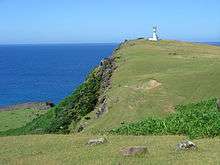
- Agarizaki (Eastern Cape)
- Irizaki (Western Cape)
- Tachigami-iwa (Standing God Rock)
- Gunkan-iwa (Battleship Rock)
- Kubura-bari (crack in the rock at Kubura)
- The open set of the TV drama series, Dr. Kotō’s Clinic
- Sanninu-dai (Sanninu Tower)
- Tōyama-jinja (Ten Mountain Shrine) – Japan’s westernmost Shinto shrine
Yonaguni Monument
- Agarizaki
 Irizaki
 Tachigami-iwa
 Gunkan-iwa
- Seafloor ruins (Yonaguni Monument)
 The open set of the TV drama series, Dr. Koto's Clinic
Animals of special significance
- Yonaguni horse – One of eight traditional Japanese horses, the smallest horse in Japan. Unable to be seen anywhere other than the island of Yonaguni.
- Atlas moth – Called ayami habiru locally, this is the world’s largest moth. In Japan, it is found only in Yonaguni.
Broadcasting
Television broadcasts consist of translator stations in Yonaguni and Uchimichi and radio broadcasts are established from the Yonaguni television translator station. It is also the only place in Japan where all three NHK Radio stations are on the FM band. In addition, Yonaguni receives Taiwanese television broadcasts (Taiwan Television(TTV), China Television(CTV), and Chinese Television System(CTS)), along with Taiwanese radio broadcasts.
List of broadcast station frequencies
TV translator frequencies
| Location | NHK General | NHK Educational | Ryukyu Broadcasting Corporation (RBC) | Okinawa Television (OTV) |
|---|---|---|---|---|
| Yonaguni | 37 | 39 | 41 | 43 |
| Uchimichi | 49 | 51 | 53 | 55 |
Radio translator frequencies (MHz)
| Location | NHK1 | NHK2 | NHK3 | Ryukyu Broadcasting Corporation (RBCi) | Radio Okinawa (ROK) |
|---|---|---|---|---|---|
| Yonaguni | 83.5 | 80.3 | 85.8 | 84.7 | 79.5 |
Other information
Through the cell towers on the east side of Taiwan that are geographically close to Yonaguni, it is possible, depending on the weather, to receive GSM phone service on Taiwanese phones from Irizaki (and it is possible that GSM phones from international carriers could use the service while roaming).
External links
| Wikivoyage has a travel guide for Yonaguni. |
- Yonaguni Homepage (in Japanese)
References
- ↑ 「与那国「国境交流特区」がめざすもの」 Archived October 6, 2006, at the Wayback Machine. (Yonaguni), page 1 (in Japanese)
- ↑ 『日本の島ガイド SHIMADAS(シマダス)』Foundation of Japanese Outlying Islands, Inc., 2004 (in Japanese)
| Wikimedia Commons has media related to Yonaguni, Okinawa. |