Saint Joseph, Barbados
| Saint Joseph | |
|---|---|
| Parish | |
 | |
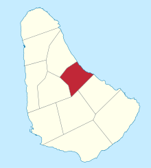 Map of Barbados showing the Saint Joseph parish | |
| Coordinates: 13°12′N 59°32′W / 13.200°N 59.533°WCoordinates: 13°12′N 59°32′W / 13.200°N 59.533°W | |
| Country | Barbados |
| Largest city | Bathsheba |
| Government | |
| • Type | Parliamentary democracy |
| • Parliamentary seats | 1 |
| Area | |
| • Total | 26 km2 (10 sq mi) |
| Population (2010 census) | |
| • Total | 6,620 |
| • Density | 250/km2 (660/sq mi) |
| ISO 3166 code | BB-06[1] |
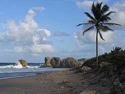
The parish of Saint Joseph is a parish of Barbados on the eastern side of the island. The parish is home to two of the more notable botanic gardens in the country - Flower Forest and Andromeda Gardens. Parts of St. Joseph are also referred to as the Scotland District, a reference to the appearance of the landscape.
One of the highest points in the island is Chimborazo in Saint Joseph. Saint Joseph is also the home of the "Soup Bowl" where international surfing competitions are held.
Geography
Settlements
- Airy Hill
- Bathsheba
- Bissex
- Blackmans
- Bonwell
- Branchbury
- Buckden House
- Canefield
- Castle Grant
- Cattlewash
- Chimborazo
- Hackleton's Cliff
Parishes bordering Saint Joseph
- Saint Andrew - North
- Saint George - South
- Saint John - Southeast
- Saint Thomas - West
References
- ↑ iso:code:3166:BB, International Organization for Standardization
| Wikimedia Commons has media related to Saint Joseph, Barbados. |
This article is issued from
Wikipedia.
The text is licensed under Creative Commons - Attribution - Sharealike.
Additional terms may apply for the media files.