Saint George, Barbados
| Saint George | |
|---|---|
| Parish | |
 | |
 Map of Barbados showing the Saint George parish | |
| Coordinates: 13°08′N 59°32′W / 13.133°N 59.533°WCoordinates: 13°08′N 59°32′W / 13.133°N 59.533°W | |
| Country | Barbados |
| Largest city | The Glebe |
| Government | |
| • Type | Parliamentary democracy |
| • Parliamentary seats | 2 |
| Area | |
| • Total | 44 km2 (17 sq mi) |
| Population (2010 census) | |
| • Total | 19,767 |
| • Density | 450/km2 (1,200/sq mi) |
| ISO 3166 code | BB-03[1] |
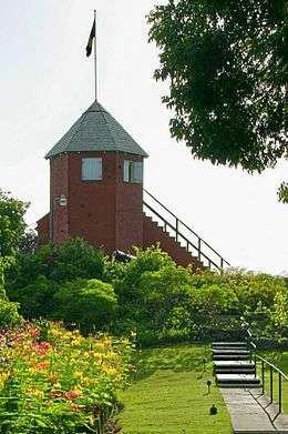
The parish of Saint George ("St. George") is located in the interior of Barbados. It is one of two land-locked parishes, the other being Saint Thomas to the north. A prominent landmark in the parish is Gun Hill Signal Station – one of the few remaining signal stations, dating back to 1818.
Saint George borders six of the eleven other parishes, more than any other parish.
Geography
Settlements
Parishes bordering Saint George
- Christ Church – South
- Saint John – Northeast
- Saint Joseph – North
- Saint Michael – West
- Saint Philip – East
- Saint Thomas – Northwest
References
- ↑ iso:code:3166:BB, International Organization for Standardization
This article is issued from
Wikipedia.
The text is licensed under Creative Commons - Attribution - Sharealike.
Additional terms may apply for the media files.