Saint John, Barbados
| Saint John | |
|---|---|
| Parish | |
 | |
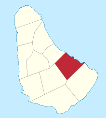 Map of Barbados showing the Saint John parish | |
| Coordinates: 13°10′N 59°29′W / 13.167°N 59.483°WCoordinates: 13°10′N 59°29′W / 13.167°N 59.483°W | |
| Country | Barbados |
| Largest city | Four Roads |
| Government | |
| • Type | Parliamentary democracy |
| • Parliamentary seats | 1 |
| Area | |
| • Total | 34 km2 (13 sq mi) |
| Population (2010 census) | |
| • Total | 8,963 |
| • Density | 260/km2 (680/sq mi) |
| ISO 3166 code | BB-05[1] |
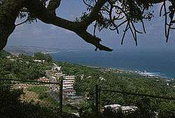
The parish of Saint John (St. John) is a parish of Barbados on the eastern side of the island. It is home to one of its secondary schools, The Lodge School. The parish is the home of many districts such as Ashford and Kendal. It is home to the St. John's Parish Church, which has a scenic view of the Atlantic Ocean from its perch near Hackleton's Cliff, which overlooks the East Coast of the island.[2] In its southeastern corner, the shoreline turns northward, forming the small Conset Bay.[3]
Society Primary is the oldest primary school on the island. It is over 100 years old and was built by the Codrington College.
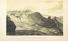
St.John's church and Hackelons cliff, 1848
Geography
Settlements
- Bath
- Bowmanston
- Carter
- Cherry Grove
- Kendal
- Saint John
- Saint Marks
Parishes bordering Saint John
- Saint George (west)
- Saint Joseph (north)
- Saint Philip (southeast)
Landmarks
Ashford Bird Park is a bird and animal sanctuary of 197 acres (80 ha).
References
- ↑ iso:code:3166:BB, International Organization for Standardization
- ↑ "Historic Churches of Barbados - St.John Parish Church". Retrieved 8 June 2016.
- ↑ Plotting location as given by this map onto this image
External links
| Wikimedia Commons has media related to Saint John, Barbados. |
This article is issued from
Wikipedia.
The text is licensed under Creative Commons - Attribution - Sharealike.
Additional terms may apply for the media files.