Saint-Ursanne
| Saint-Ursanne | ||
|---|---|---|
| Former municipality of Switzerland | ||
 | ||
| ||
 Saint-Ursanne | ||
|
Location of Saint-Ursanne 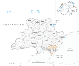 Saint-Ursanne Saint-Ursanne (Canton of Jura) | ||
| Coordinates: 47°22′N 7°09′E / 47.367°N 7.150°ECoordinates: 47°22′N 7°09′E / 47.367°N 7.150°E | ||
| Country | Switzerland | |
| Canton | Jura | |
| District | Porrentruy | |
| Area | ||
| • Total | 11.46 km2 (4.42 sq mi) | |
| Elevation | 440 m (1,440 ft) | |
| Population | ||
| • Total | 730 | |
| • Density | 64/km2 (160/sq mi) | |
| Postal code | 2882 | |
| SFOS number | 6804 | |
| Surrounded by | Seleute, Ocourt, Montmelon, Asuel, Montenol, Saint-Brais, Epauvillers | |
| Twin towns | La Motte, Var (France) | |
| Website |
www SFSO statistics | |

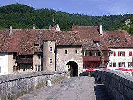
Saint-Ursanne is an old town and a former municipality of the district of Porrentruy in the canton of Jura, Switzerland which has preserved much of its medieval character. The town contains many historical buildings, including a Romanesque abbey church, a collegiate church, a cloister, many medieval houses, a hermitage and an 18th-century bridge. The river Doubs makes a loop near Saint-Ursanne before flowing into France. Since 2009 Saint-Ursanne has been a part of the new municipality Clos du Doubs.[1]
The town is famous for the medieval festival which it organizes each summer,[2] and for the annual St-Ursanne - Les Rangiers International Hill Climb in August.[3][4]
Its name refers to Saint Ursicinus, a seventh-century monk who built a monastery here.
References
- ↑ Amtliches Gemeindeverzeichnis der Schweiz. Ausgabe vom 3. Oktober 2008
- ↑ "Les Médiévales, St-Ursanne". Canton of Jura Tourism. Retrieved 28 August 2016.
- ↑ "Hill climb, Les Rangiers". Canton of Jura Tourism. Retrieved 28 August 2016.
- ↑ Kelly, Peter. "Ascend To The Green Heaven In St. Ursanne". Speedhunters. Retrieved 28 August 2016.
External links
- Events and Culture program in St-Ursanne
- "Saint-Ursanne La Fantastique !" a fantasy fair for Summer 2011, with the collaboration of the illustrator Grzegorz Rosinski
| Wikimedia Commons has media related to Saint-Ursanne. |