Montmelon
| Montmelon | ||
|---|---|---|
| Former municipality of Switzerland | ||
| ||
 Montmelon | ||
|
Location of Montmelon  Montmelon Montmelon (Canton of Jura) | ||
| Coordinates: 47°21′N 07°11′E / 47.350°N 7.183°ECoordinates: 47°21′N 07°11′E / 47.350°N 7.183°E | ||
| Country | Switzerland | |
| Canton | Jura | |
| District | Porrentruy | |
| Area | ||
| • Total | 11.97 km2 (4.62 sq mi) | |
| Elevation | 594 m (1,949 ft) | |
| Population | ||
| • Total | 114 | |
| • Density | 9.5/km2 (25/sq mi) | |
| Postal code | 2883 | |
| SFOS number | 6797 | |
| Localities | Montmelon-Dessus, Montmelon-Dessous, Ravines | |
| Surrounded by | Asuel, Saint-Ursanne, Montenol, Epauvillers, Saint-Brais, Glovelier, Boécourt, Cornol, Courgenay, Seleute, Ocourt | |
| Website |
SFSO statistics | |

Montmelon is a village and former municipality in the district of Porrentruy in the canton of Jura in Switzerland. Since January 1, 2009 it is a part of the new municipality Clos du Doubs.
References
The municipality was composed of several villages (Montmelon-Dessus, Montmelon-dessous, Ravines) and of many dispersed farms. The municipality had approximately 100 inhabitants, many of whom are farmers.
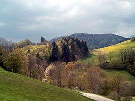
Montmelon, Doubs, Jura in spring.
| Wikimedia Commons has media related to Montmelon. |
This article is issued from
Wikipedia.
The text is licensed under Creative Commons - Attribution - Sharealike.
Additional terms may apply for the media files.