Sai Yok District
| Sai Yok ไทรโยค | |
|---|---|
| Amphoe | |
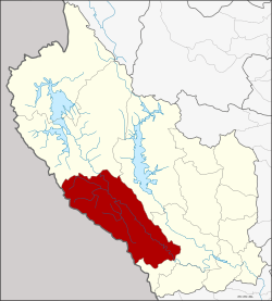 Amphoe location in Kanchanaburi Province | |
| Coordinates: 14°6′56″N 99°8′40″E / 14.11556°N 99.14444°ECoordinates: 14°6′56″N 99°8′40″E / 14.11556°N 99.14444°E | |
| Country | Thailand |
| Province | Kanchanaburi |
| Tambon | 7 |
| Muban | 57 |
| Area | |
| • Total | 2,728.922 km2 (1,053.643 sq mi) |
| Population (2015) | |
| • Total | 62,212 |
| • Density | 18.9/km2 (49/sq mi) |
| Time zone | UTC+7 (ICT) |
| Postal code | 71150 |
| Geocode | 7102 |
Sai Yok (Thai: ไทรโยค, pronounced [sāj jôːk]) is a district (amphoe) in Kanchanaburi Province in western Thailand.
Geography
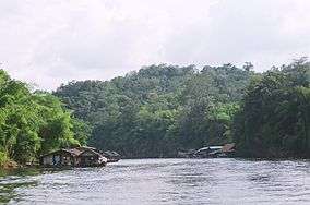
The district is in the valley of the Khwae Noi River in the Tenasserim Hills area. It borders Myanmar to the south. Along the river the Death Railway runs to Nam Tok Sai Yok Noi.
Sai Yok National Park was created on 27 October 1980 and covers an area of about 500 km2. The most famous sight in the park is the Sai Yok waterfall.
Neighboring districts are (from north clockwise) Thong Pha Phum, Si Sawat, Mueang Kanchanaburi of Kanchanaburi Province and Tanintharyi Division of Myanmar.
Sights
Apart from the nature of the Kwae Noi River valley, the other main attraction is Mueang Sing Historical Park, which shows the westernmost Khmer-style temple complex. Also popular for tourists is the Tiger Temple.
Administration
Central administration
Sai Yok is divided into seven sub-districts (tambon), which are further subdivided into 57 administrative villages (Muban).
| No. | Name | Thai | Villages | Pop.[1] |
|---|---|---|---|---|
| 1. | Lum Sum | ลุ่มสุ่ม | 11 | 10,580 |
| 2. | Tha Sao | ท่าเสา | 11 | 13,584 |
| 3. | Sing | สิงห์ | 6 | 4,805 |
| 4. | Sai Yok | ไทรโยค | 8 | 10,449 |
| 5. | Wang Krachae | วังกระแจะ | 9 | 9,134 |
| 6. | Si Mongkhon | ศรีมงคล | 8 | 7,840 |
| 7. | Bongti | บ้องตี้ | 4 | 5,820 |
Local administration
There are three sub-district municipalities (thesaban tambon) in the district:
- Nam Tok Sai Yok Noi (Thai: เทศบาลตำบลน้ำตกไทรโยคน้อย) consisting of parts of sub-district Tha Sao.
- Wang Pho (Thai: เทศบาลตำบลวังโพธิ์) consisting of parts of sub-district Lum Sum.
- Sai Yok (Thai: เทศบาลตำบลไทรโยค) consisting of sub-district Sai Yok.
There are six sub-district administrative organizations (SAO) in the district:
- Lum Sum (Thai: องค์การบริหารส่วนตำบลลุ่มสุ่ม) consisting of parts of sub-district Lum Sum.
- Tha Sao (Thai: องค์การบริหารส่วนตำบลท่าเสา) consisting of parts of sub-district Tha Sao.
- Sing (Thai: องค์การบริหารส่วนตำบลสิงห์) consisting of sub-district Sing.
- Wang Krachae (Thai: องค์การบริหารส่วนตำบลวังกระแจะ) consisting of sub-district Wang Krachae.
- Si Mongkhon (Thai: องค์การบริหารส่วนตำบลศรีมงคล) consisting of sub-district Si Mongkhon.
- Bongti (Thai: องค์การบริหารส่วนตำบลบ้องตี้) consisting of sub-district Bongti.
Popular culture
- Sai Yok was the location of shooting the Vietnam scenes of the 1978 film The Deer Hunter.
- Sai Yok was mentioned in the song "Mon Sai Yok" (มนต์ไทรโยค - "Magic Of Sai Yok") by the Thai pop rock band The Innocent from an album Yu Hor (อยู่หอ - Stay Dorm) in 1982. The song is about a delightful time in Sai Yok.
References
- ↑ "Population statistics 2015" (in Thai). Department of Provincial Administration. Retrieved 2016-06-10.
External links
| Wikimedia Commons has media related to Sai Yok District. |
