Sahul Shelf
Geologically, the Sahul Shelf /səˈhuːl/ is part of the continental shelf of the Australian continent and lies off the coast of mainland Australia.
Etymology
The name "Sahull" or "Sahoel" appeared on 17th century Dutch maps applied to a submerged sandbank between Australia and Timor. On his 1803 map, Matthew Flinders noted the "Great Sahul Shoal" where Malays came from Makassar to fish for trepang (sea cucumber).[1] The Sahul and Sunda shelves were given their present names by G.A.F. Molengraaff and Max Wilhelm Carl Weber in 1919.[1]
Geography
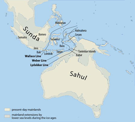
The Sahul Shelf proper stretches northwest from Australia much of the way under the Timor Sea towards Timor, ending where the seabed begins descending into the Timor Trough. Another part of the Sahul Shelf is known also as the Arafura Shelf and runs all the way from the northern coast of Australia under the Arafura Sea to New Guinea. The Aru Islands rise from the Arafura Shelf. The Sahul Shelf is sometimes taken to also include the Rowley Shelf which runs out under the Indian Ocean from the northwest coast of Australia as far south as North West Cape.
The existence of the much larger Sahul Shelf was suggested in 1845 by G.W. Earl who called it the "Great Australian Bank" and noted that macropods (kangaroos) were found on Australia, New Guinea, and the Aru Islands. Earl also suggested the existence of the Sunda Shelf which he called the "Great Asiatic Bank".[2]
Geology
When sea levels fell during the Pleistocene ice age, including the last glacial maximum about 18,000 years ago, the Sahul Shelf was exposed as dry land. Evidence of the shoreline of this time has been identified in locations which now lie 100 to 140 metres below sea level.[3] A Flash-based interactive timeline of sea level changes was developed by Monash University in the 2000s.[4] The Arafura Shelf formed a land bridge between Australia, New Guinea, and the Aru Islands, and these lands share many marsupial mammals, land birds, and freshwater fish as a result. Lydekker's Line, a biogeographical line, runs along the edge of Sahul Shelf where it drops off into the deep waters of the Wallacea biogeographical area. Wallacea sits in a gap between the Sahul Shelf and the Sunda Shelf, part of the continental shelf of Southeast Asia.[5]
See also
References
- 1 2 Ballard, Chris (1993). "Stimulating minds to fantasy? A critical etymology for Sahul". Sahul in review: pleistocene archaeology in Australia, New Guinea and island Melanesia. Canberra: Australian National University. p. 17. ISBN 0-7315-1540-4.
- ↑ Earle, W. (G.W. Earl) (1845). "On the physical structure and arrangement of the islands of the Indian Archipelago". Journal of the Royal Geographical Society. Journal of the Royal Geographical Society of London, Vol. 15. 15: 358–365. doi:10.2307/1797916. JSTOR 1797916.
- ↑ "Big Bank Shoals of the Timor Sea: An environmental resource atlas". Australian Institute of Marine Science. 2001. Retrieved 2006-08-28.
- ↑ Monash University. "SahulTime". Retrieved 2008-07-22.
- ↑ Wirantaprawira, Willy (2003). "Republik Indonesia. Geography". Wirantaprawira. Retrieved 2006-08-28.