Sabula, Missouri
| Sabula, Missouri | |
|---|---|
| Unincorporated community | |
 Sabula  Sabula | |
| Coordinates: 37°24′17″N 90°41′46″W / 37.40472°N 90.69611°WCoordinates: 37°24′17″N 90°41′46″W / 37.40472°N 90.69611°W | |
| Country | United States |
| State | Missouri |
| County | Iron |
| Elevation | 689 ft (210 m) |
| Time zone | UTC-6 (Central (CST)) |
| • Summer (DST) | UTC-5 (CDT) |
| Area code(s) | 573 |
| GNIS feature ID | 751995[1] |
Sabula is an unincorporated community in Iron County, in the U.S. state of Missouri.[1]
History
Sabula was originally called Reynolds, and under the latter name was platted in 1873 when the railroad was extended to that point.[2] A post office called Sabula was established in 1884, and remained in operation until 1953.[3]
References
- 1 2 U.S. Geological Survey Geographic Names Information System: Sabula, Missouri
- ↑ "Iron County Place Names, 1928–1945 (archived)". The State Historical Society of Missouri. Archived from the original on 24 June 2016. Retrieved 12 October 2016.
- ↑ "Post Offices". Jim Forte Postal History. Retrieved 12 October 2016.
Municipalities and communities of Iron County, Missouri, United States | ||
|---|---|---|
| Cities | 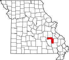 | |
| Village | ||
| Townships | ||
| Unincorporated communities | ||
| Ghost towns | ||
| Footnotes | ‡This populated place also has portions in an adjacent county or counties | |
This article is issued from
Wikipedia.
The text is licensed under Creative Commons - Attribution - Sharealike.
Additional terms may apply for the media files.