Minimum, Missouri
| Minimum, Missouri | |
|---|---|
| Unincorporated community | |
 Minimum  Minimum | |
| Coordinates: 37°22′34″N 90°35′15″W / 37.37611°N 90.58750°WCoordinates: 37°22′34″N 90°35′15″W / 37.37611°N 90.58750°W | |
| Country | United States |
| State | Missouri |
| County | Iron |
| Elevation | 607 ft (185 m) |
| Time zone | UTC-6 (Central (CST)) |
| • Summer (DST) | UTC-5 (CDT) |
| Area code(s) | 573 |
| GNIS feature ID | 751119[1] |
Minimum is an unincorporated community in southeastern Iron County, in the U.S. state of Missouri.[1]
The community lies on the banks of Crane Pond Creek just north of that stream's confluence with Sulphur Creek. It is at the intersection of Missouri Route C and County Road 134. The town of Annapolis on Missouri Route 49 is about six miles to the west.[2]
History
A post office called Minimum was established in 1904, and remained in operation until 1955.[3] The name "Minimum" is said to be derived from the first name of Minnie Farr, the wife of an early postmaster.[4]
References
- 1 2 U.S. Geological Survey Geographic Names Information System: Minimum, Missouri
- ↑ Missouri Atlas & Gazetteer, DeLorme, 1998, First edition, p. 56, ISBN 0-89933-224-2
- ↑ "Post Offices". Jim Forte Postal History. Retrieved 12 October 2016.
- ↑ "Iron County Place Names, 1928–1945 (archived)". The State Historical Society of Missouri. Archived from the original on 24 June 2016. Retrieved 12 October 2016.
Municipalities and communities of Iron County, Missouri, United States | ||
|---|---|---|
| Cities | 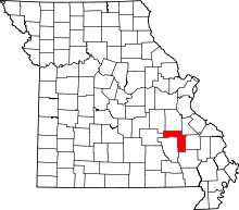 | |
| Village | ||
| Townships | ||
| Unincorporated communities | ||
| Ghost towns | ||
| Footnotes | ‡This populated place also has portions in an adjacent county or counties | |
This article is issued from
Wikipedia.
The text is licensed under Creative Commons - Attribution - Sharealike.
Additional terms may apply for the media files.