Sabu Raijua Regency
| Sabu Raijua Regency Kabupaten Sabu Raijua | ||
|---|---|---|
| Regency | ||
| ||
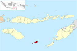 Location within East Nusa Tenggara | ||
 Sabu Raijua Regency Location in Lesser Sunda Islands and Indonesia  Sabu Raijua Regency Sabu Raijua Regency (Indonesia) | ||
| Coordinates: 10°33′46″S 121°47′20″E / 10.5629°S 121.7889°ECoordinates: 10°33′46″S 121°47′20″E / 10.5629°S 121.7889°E | ||
| Country |
| |
| Region | Lesser Sunda Islands | |
| Province |
| |
| Capital | West Savu | |
| Government | ||
| • Regent | Nikodemus Rihi Heke | |
| • Vice Regent | vacant | |
| Area | ||
| • Total | 177.93 sq mi (460.84 km2) | |
| Population (2010) | ||
| • Total | 72,960 | |
| • Density | 410/sq mi (160/km2) | |
| Area code | (+62) 380 | |
| Website | saburaijuakab.go.id | |

Sabu Raijua Regency is one of the regencies in the province of East Nusa Tenggara, Indonesia. It comprises the three Savu Islands, lying between Sumba and Rote Island in the Savu Sea. The regency was established by Indonesia's Minister of Home Affairs, Mardiyanto, on 29 October 2008, partitioned from Kupang Regency. The population was 72,960 at the 2010 census.[1]
Administration
The regency is divided into six districts (kecamatan), tabulated below with their 2010 Census population.
| Name | English name | Population Census 2010 |
|---|---|---|
| Raijua | Raijua Island | 7,671 |
| Hawu Mehara | 15,361 | |
| Sabu Liae | 8,847 | |
| Sabu Barat | West Savu | 26,463 |
| Sabu Tengah | Central Savu | 7,165 |
| Sabu Timur | East Savu | 7,453 |
References
Regencies and cities of East Nusa Tenggara | ||
|---|---|---|
Capital: Kupang | ||
| Regencies |  | |
| Cities | ||
This article is issued from
Wikipedia.
The text is licensed under Creative Commons - Attribution - Sharealike.
Additional terms may apply for the media files.