Manggarai Regency
| Manggarai Regency Kabupaten Manggarai | ||
|---|---|---|
| Regency | ||
| ||
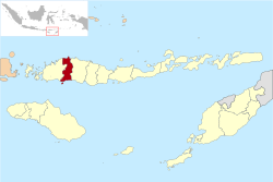 Location within East Nusa Tenggara | ||
 Manggarai Regency  Manggarai Regency Manggarai Regency (Lesser Sunda Islands)  Manggarai Regency Manggarai Regency (Indonesia) | ||
| Coordinates: 8°36′46″S 120°27′45″E / 8.6127°S 120.4626°ECoordinates: 8°36′46″S 120°27′45″E / 8.6127°S 120.4626°E | ||
| Country |
| |
| Province |
| |
| Capital | Ruteng | |
| Government | ||
| • Regent | Deno Kamelus | |
| • Vice Regent | Victor Madur | |
| Area | ||
| • Total | 651 sq mi (1,687 km2) | |
| Population (2010 Census) | ||
| • Total | 292,037 | |
| Area code | (+62) 385 | |
| Website |
manggaraikab | |
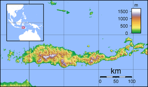
Manggarai regency is a regency in East Nusa Tenggara province of Indonesia, situated on the island of Flores. Established in 1958[1] the regency was reduced in size and population by the separation of Manggarai Barat regency in 2003 and of Manggarai Timur regency in 2007. The capital of the regency is Ruteng.
The Liang Bua archeological site is in Manggarai regency, about 10 km to the north of Ruteng.
Administration
Manggarai regency is now divided into nine districts (kecamatan), tabulated below with their 2010 Census population.
| Name | Population Census 2010 |
|---|---|
| Satar Mese | 30,583 |
| Satar Mese Barat (West Satar Mese) | 30,044 |
| Langke Rembong | 66,364 |
| Ruteng | 38,888 |
| War Rii | 25,596 |
| Lelak | 10,821 |
| Rahong Utara (North Rahong) | 20,659 |
| Cibal | 37,800 |
| Reok | 30,320 |
| Total | 292,037 |
References
- ↑
Government of Indonesia (9 August 1958), Establishment of the Second-level Administrative Regions under the First-level Administrative Region of Bali, West Nusa Tenggara and East Nusa Tenggara (in Indonesian), Indonesia Ministry of Law and Justice, UU No. 69/1958
|access-date=requires|url=(help)
Regencies and cities of East Nusa Tenggara | ||
|---|---|---|
Capital: Kupang | ||
| Regencies |  | |
| Cities | ||
This article is issued from
Wikipedia.
The text is licensed under Creative Commons - Attribution - Sharealike.
Additional terms may apply for the media files.